|
|
|
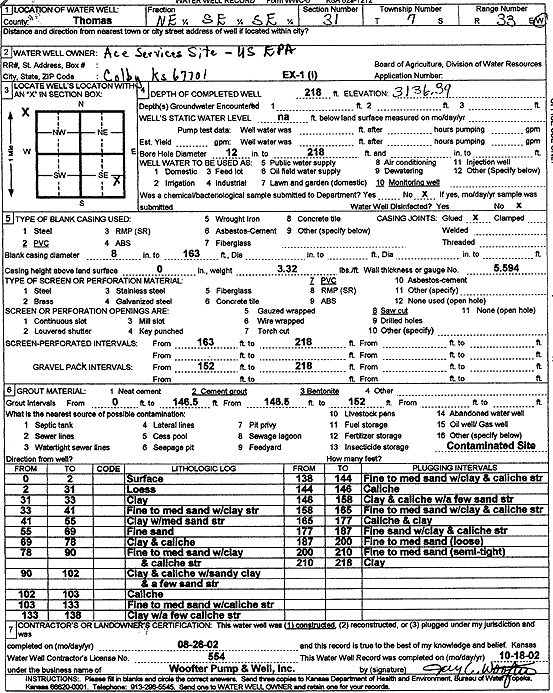
Specific Water Well Detail |
|
|
| Location Info | |||
| Owner: U.S. EPA Region 7, Ace Services Site | Status: Constructed | ||
| Location: T7S, R33W, Sec. 31, NE SE SE | County: Thomas | ||
| Directions: | |||
| Latitude: 39.3970297 | Longitude: -101.037137 | Datum NAD 27 | |
| Latitude: 39.3970334 | Longitude: -101.0375697 | Datum NAD 83 | |
| Longitude and latitude calculated by Survey from township-range-section-quarter calls. Only good to within the quarter call accuracy. | |||
| View well on interactive map | |||
| General Info | ||
| Well Depth: 218 ft. | Elevation: 3136.39 ft. | |
| Static Water Level: ft. | Est. Yield: gpm. | |
| Comp. Date: 26-Aug-2002 | Well Use: Monitoring well/observation/piezometer | |
| DWR Applic. #: | Other ID: EX 1 I | |
| Driller Info | ||
| Driller: Jay C. Woofter Pump & Well, Inc. | License #: 554 | |
| Scanned Form | View scan |
|
Chemical Sample Submitted?:
Water Well disinfected?: | ||
| Casing Info | ||
| Casing Type:
Casing Joints: |
Diam: in. to ft | |
| Casing height above land surface: in
Casing Weight: lbs/ft Wall thickness or gauge no.: | ||
| Screen and Perforation Info | ||
| Screen Type: | Screen Openings: | |
| Screen-perforated intervals | From: ft to ft | |
| Gravel pack intervals | From: ft to ft | |
| Grout Info | ||
| Grout used: | From: to ft | |
| Source of Possible Contamination | ||
| Source: | ||
| Direction from well: | Distance: ft | |
| Lithologic Log
(Log data entered by KGS.) | ||
| From: 0 ft. to 2 ft. | surface | |
| From: 2 ft. to 31 ft. | loess | |
| From: 31 ft. to 33 ft. | clay | |
| From: 33 ft. to 41 ft. | fine to medium sand with clay streaks | |
| From: 41 ft. to 55 ft. | clay with medium sand streaks | |
| From: 55 ft. to 69 ft. | fine sand | |
| From: 69 ft. to 78 ft. | clay and caliche | |
| From: 78 ft. to 90 ft. | fine to medium sand with clay and caliche streaks | |
| From: 90 ft. to 102 ft. | clay and caliche with sandy and a few sand streaks | |
| From: 102 ft. to 103 ft. | caliche | |
| From: 103 ft. to 133 ft. | fine to medium sand with caliche streaks | |
| From: 133 ft. to 138 ft. | clay with a few caliche streaks | |
| From: 138 ft. to 144 ft. | fine to medium sand with clay and caliche streaks | |
| From: 144 ft. to 146 ft. | caliche | |
| From: 146 ft. to 158 ft. | clay and caliche with a few sand streaks | |
| From: 158 ft. to 165 ft. | fine to medium sand with clay and caliche streaks | |
| From: 165 ft. to 177 ft. | caliche and clay | |
| From: 177 ft. to 187 ft. | fine sand with clay and caliche streaks | |
| From: 187 ft. to 200 ft. | fine to medium sand, loose | |
| From: 200 ft. to 210 ft. | fine to medium sand, semi-tight | |
| From: 210 ft. to 218 ft. | clay | |