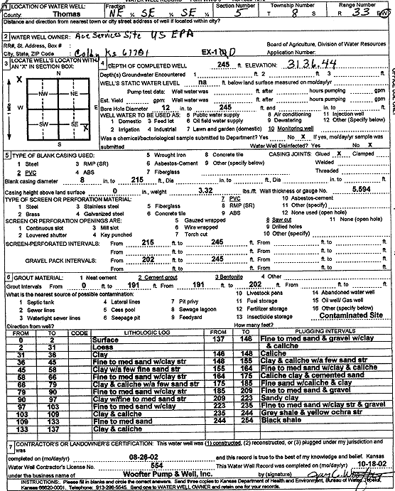
KGS Home Page Water Well Data base Specific Water Well Detail
Water Resources

Well T8S, R33W, Sec. 5, NE SE SE, Action: Constructed

Location Info
Owner: U.S. EPA Region 7, Ace Services Site Status: Constructed
Location: T8S, R33W, Sec. 5, NE SE SE County: Thomas
Directions:
Latitude: 39.3825978 Longitude: -101.0184729 Datum NAD 27
Latitude: 39.3826018 Longitude: -101.0189051 Datum NAD 83
Longitude and latitude calculated by Survey from township-range-section-quarter calls. Only good to within the quarter call accuracy.
View well on interactive map
General Info
Well Depth: 245 ft. Elevation: 3136.44 ft.
Static Water Level: ft. Est. Yield: gpm.
Comp. Date: 26-Aug-2002 Well Use: Monitoring well/observation/piezometer
DWR Applic. #: Other ID: EX 1 D
Driller Info
Driller: Jay C. Woofter Pump & Well, Inc. License #: 554
Scanned Form
View form(s) on screen Download scan(s)
The download files contain one or more TIFF images compressed into a ZIP archive. Your browser may be already set up to decompress these files. The TIFFs are 300 dpi archival-quality scans of the WWC5 forms and can be viewed by software like Adobe PhotoShop.
Chemical Sample Submitted?:
Water Well disinfected?:
Casing Info
Casing Type:
Casing Joints:
Diam: in. to ft
Casing height above land surface: in
Casing Weight: lbs/ft
Wall thickness or gauge no.:
Screen and Perforation Info
Screen Type: Screen Openings:
Screen-perforated intervals From: ft to ft
Gravel pack intervals From: ft to ft
Grout Info
Grout used: From: to ft
Source of Possible Contamination
Source:
Direction from well: Distance: ft
Lithologic Log
(Log data entered by KGS.)
From: 0 ft. to 2 ft. surface
From: 2 ft. to 31 ft. loess
From: 31 ft. to 36 ft. clay
From: 36 ft. to 45 ft. fine to medium sand with clay streaks
From: 45 ft. to 58 ft. clay with a few fine sand streaks
From: 58 ft. to 66 ft. fine to medium sand with clay streaks
From: 66 ft. to 79 ft. clay and caliche with a few sand streaks
From: 79 ft. to 90 ft. fine to medium sand with clay streaks
From: 90 ft. to 97 ft. clay with fine to medium sand streaks
From: 97 ft. to 103 ft. fine to medium sand with clay
From: 103 ft. to 109 ft. clay and caliche
From: 109 ft. to 133 ft. fine to medium sand
From: 133 ft. to 137 ft. clay and caliche
From: 137 ft. to 146 ft. fine to medium sand and gravel with clay and caliche
From: 146 ft. to 148 ft. caliche
From: 148 ft. to 155 ft. clay and caliche with a few sand streaks
From: 155 ft. to 164 ft. fine to medium sand with clay and caliche
From: 164 ft. to 175 ft. caliche, clay, and cemented sand
From: 175 ft. to 185 ft. fine sand with caliche and clay
From: 185 ft. to 209 ft. fine to medium sand and gravel
From: 209 ft. to 223 ft. sandy clay
From: 223 ft. to 235 ft. fine to medium sand with clay streaks and gravel
From: 235 ft. to 244 ft. gray shale and yellow ochre streaks
From: 244 ft. to 254 ft. black shale

Kansas Geological Survey
Comments to kgs-webadmin@ku.edu
URL=http://www.kgs.ku.edu/Magellan/WaterWell/index.html
Display Programs Updated January 2, 2025
Data added continuously.