|
|
|
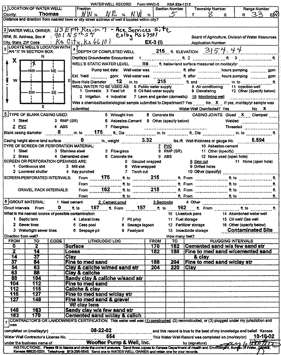
Specific Water Well Detail |
|
|
| Location Info | |||
| Owner: U.S. EPA Region 7, Ace Services Site | Status: Constructed | ||
| Location: T8S, R33W, Sec. 5, NW NE NW | County: Thomas | ||
| Directions: | |||
| Latitude: 39.3933953 | Longitude: -101.0301496 | Datum NAD 27 | |
| Latitude: 39.3933991 | Longitude: -101.0305821 | Datum NAD 83 | |
| Longitude and latitude calculated by Survey from township-range-section-quarter calls. Only good to within the quarter call accuracy. | |||
| View well on interactive map | |||
| General Info | ||
| Well Depth: 215 ft. | Elevation: 3154.44 ft. | |
| Static Water Level: ft. | Est. Yield: gpm. | |
| Comp. Date: 22-Aug-2002 | Well Use: Monitoring well/observation/piezometer | |
| DWR Applic. #: | Other ID: EX 3 I | |
| Driller Info | ||
| Driller: Jay C. Woofter Pump & Well, Inc. | License #: 554 | |
| Scanned Form | View scan |
|
Chemical Sample Submitted?:
Water Well disinfected?: | ||
| Casing Info | ||
| Casing Type:
Casing Joints: |
Diam: in. to ft | |
| Casing height above land surface: in
Casing Weight: lbs/ft Wall thickness or gauge no.: | ||
| Screen and Perforation Info | ||
| Screen Type: | Screen Openings: | |
| Screen-perforated intervals | From: ft to ft | |
| Gravel pack intervals | From: ft to ft | |
| Grout Info | ||
| Grout used: | From: to ft | |
| Source of Possible Contamination | ||
| Source: | ||
| Direction from well: | Distance: ft | |
| Lithologic Log
(Log data entered by KGS.) | ||
| From: 0 ft. to 2 ft. | surface | |
| From: 2 ft. to 14 ft. | loess | |
| From: 14 ft. to 37 ft. | clay | |
| From: 37 ft. to 54 ft. | fine to medium sand | |
| From: 54 ft. to 63 ft. | clay and caliche with medium sand streak | |
| From: 63 ft. to 88 ft. | clay and caliche | |
| From: 88 ft. to 104 ft. | sandy clay and caliche with sand streak | |
| From: 104 ft. to 112 ft. | fine to medium sand | |
| From: 112 ft. to 115 ft. | caliche and clay | |
| From: 115 ft. to 127 ft. | fine to medium sand with clay streaks | |
| From: 127 ft. to 148 ft. | fine to medium sand and gravel with clay lens | |
| From: 148 ft. to 163 ft. | sandy clay with a few sand streaks | |
| From: 163 ft. to 170 ft. | cemented sand with clay and caliche | |
| From: 170 ft. to 182 ft. | cemented sand with a few sand streaks | |
| From: 182 ft. to 188 ft. | fine to medium sand with cemented sand and clay | |
| From: 188 ft. to 204 ft. | fine to medium sand with clay streaks | |
| From: 204 ft. to 220 ft. | clay | |