|
|
|
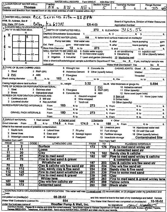
Specific Water Well Detail |
|
|
| Location Info | |||
| Owner: U.S. EPA Region 7, Ace Services Site | Status: Constructed | ||
| Location: T8S, R33W, Sec. 5, NW NW NE | County: Thomas | ||
| Directions: | |||
| Latitude: 39.3933826 | Longitude: -101.0254423 | Datum NAD 27 | |
| Latitude: 39.3933864 | Longitude: -101.0258747 | Datum NAD 83 | |
| Longitude and latitude calculated by Survey from township-range-section-quarter calls. Only good to within the quarter call accuracy. | |||
| View well on interactive map | |||
| General Info | ||
| Well Depth: 273 ft. | Elevation: 3163.56 ft. | |
| Static Water Level: ft. | Est. Yield: gpm. | |
| Comp. Date: 28-Aug-2002 | Well Use: Monitoring well/observation/piezometer | |
| DWR Applic. #: | Other ID: EX 4 I | |
| Driller Info | ||
| Driller: Jay C. Woofter Pump & Well, Inc. | License #: 554 | |
| Scanned Form | View scan |
|
Chemical Sample Submitted?:
Water Well disinfected?: | ||
| Casing Info | ||
| Casing Type:
Casing Joints: |
Diam: in. to ft | |
| Casing height above land surface: in
Casing Weight: lbs/ft Wall thickness or gauge no.: | ||
| Screen and Perforation Info | ||
| Screen Type: | Screen Openings: | |
| Screen-perforated intervals | From: ft to ft | |
| Gravel pack intervals | From: ft to ft | |
| Grout Info | ||
| Grout used: | From: to ft | |
| Source of Possible Contamination | ||
| Source: | ||
| Direction from well: | Distance: ft | |
| Lithologic Log
(Log data entered by KGS.) | ||
| From: 0 ft. to 2 ft. | surface | |
| From: 2 ft. to 11 ft. | loess | |
| From: 11 ft. to 30 ft. | clay | |
| From: 30 ft. to 41 ft. | fine to medium sand | |
| From: 41 ft. to 70 ft. | fine to medium sand and gravel | |
| From: 70 ft. to 83 ft. | clay and caliche with a few sand streaks | |
| From: 83 ft. to 112 ft. | clay, sandy clay, and fine sand | |
| From: 112 ft. to 125 ft. | fine to medium sand with caliche streaks | |
| From: 125 ft. to 157 ft. | fine to medium sand and gravel with clay lens | |
| From: 157 ft. to 169 ft. | clay with a few caliche streaks | |
| From: 169 ft. to 173 ft. | cemented sand | |
| From: 173 ft. to 176 ft. | fine to medium sand with clay streaks and cemented sand streaks | |
| From: 176 ft. to 182 ft. | sandy clay and caliche | |
| From: 182 ft. to 197 ft. | fine to medium sand with clay and caliche and cemented sand | |
| From: 197 ft. to 203 ft. | clay and caliche with a few sand streaks | |
| From: 203 ft. to 224 ft. | clay with a few sand streaks | |
| From: 224 ft. to 235 ft. | sandy clay and fine sand | |
| From: 235 ft. to 239 ft. | fine to some medium sand | |
| From: 239 ft. to 245 ft. | clay | |
| From: 245 ft. to 263 ft. | fine to medium sand and gravel with clay lens | |
| From: 263 ft. to 269 ft. | yellow ochre | |
| From: 269 ft. to 280 ft. | black shale | |