|
|
|
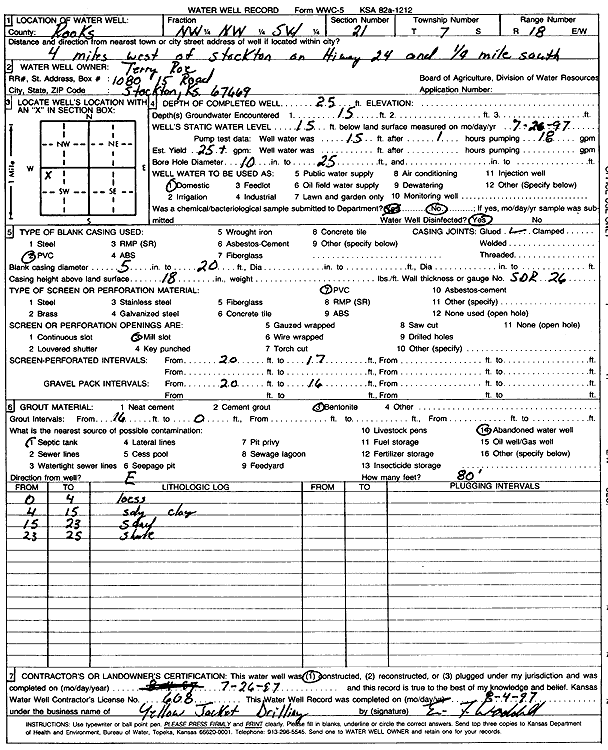
Specific Water Well Detail |
|
|
| Location Info | |||
| Owner: Roe, Terry | Status: Constructed | ||
| Location: T7S, R18W, Sec. 21, NW NW SW | County: Rooks | ||
| Directions: from Stockton: 4 mi W on Hwy 24, .25 mi S | |||
| Latitude: 39.4293034 | Longitude: -99.3409867 | Datum NAD 27 | |
| Latitude: 39.4293129 | Longitude: -99.3413642 | Datum NAD 83 | |
| Longitude and latitude calculated by Survey from township-range-section-quarter calls. Only good to within the quarter call accuracy. | |||
| View well on interactive map | |||
| General Info | ||
| Well Depth: 25 ft. | Elevation: ft. | |
| Static Water Level: 15 ft. | Est. Yield: 25 gpm. | |
| Comp. Date: 26-Jul-1997 | Well Use: Domestic | |
| DWR Applic. #: | Other ID: | |
| Driller Info | ||
| Driller: Yellow Jacket Drilling | License #: 608 | |
| Scanned Form | View scan |
|
Chemical Sample Submitted?:
Water Well disinfected?: | ||
| Casing Info | ||
| Casing Type:
Casing Joints: |
Diam: in. to ft | |
| Casing height above land surface: in
Casing Weight: lbs/ft Wall thickness or gauge no.: | ||
| Screen and Perforation Info | ||
| Screen Type: | Screen Openings: | |
| Screen-perforated intervals | From: ft to ft | |
| Gravel pack intervals | From: ft to ft | |
| Grout Info | ||
| Grout used: | From: to ft | |
| Source of Possible Contamination | ||
| Source: | ||
| Direction from well: | Distance: ft | |
| Lithologic Log
(Log data entered by KGS.) | ||
| From: 0 ft. to 4 ft. | loess | |
| From: 4 ft. to 15 ft. | sandy clay | |
| From: 15 ft. to 23 ft. | sandy | |
| From: 23 ft. to 25 ft. | shale | |