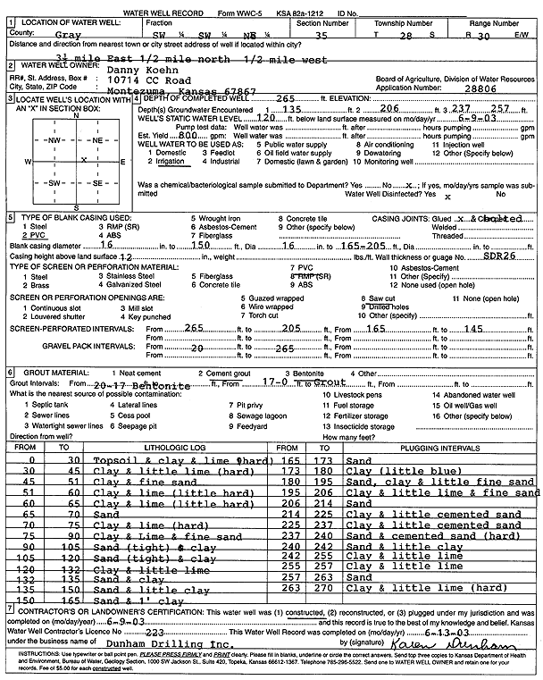
Lithologic Log
(Log data entered by KGS.) |
| |
From: 0 ft. to 30 ft. |
Topsoil and clay and lime (hard) |
| |
From: 30 ft. to 45 ft. |
Clay and little lime (hard) |
| |
From: 45 ft. to 51 ft. |
Clay and fine sand |
| |
From: 51 ft. to 60 ft. |
Clay and lime (little hard) |
| |
From: 60 ft. to 65 ft. |
Clay and lime (little hard) |
| |
From: 65 ft. to 70 ft. |
Sand |
| |
From: 70 ft. to 75 ft. |
Clay and lime (hard) |
| |
From: 75 ft. to 90 ft. |
Clay and Lime and fine sand |
| |
From: 90 ft. to 105 ft. |
Sand (tight) and clay |
| |
From: 105 ft. to 120 ft. |
Sand (tight) and clay |
| |
From: 120 ft. to 132 ft. |
Clay and little lime |
| |
From: 132 ft. to 135 ft. |
Sand and clay |
| |
From: 135 ft. to 150 ft. |
Sand and little clay |
| |
From: 150 ft. to 165 ft. |
Sand and 1 foot clay |
| |
From: 165 ft. to 173 ft. |
Sand |
| |
From: 173 ft. to 180 ft. |
Clay (little blue) |
| |
From: 180 ft. to 195 ft. |
Sand, clay and little fine sand |
| |
From: 195 ft. to 206 ft. |
Clay and little lime and fine sand |
| |
From: 206 ft. to 214 ft. |
Sand |
| |
From: 214 ft. to 225 ft. |
Clay and little cemented sand |
| |
From: 225 ft. to 237 ft. |
Clay and little cemented sand |
| |
From: 237 ft. to 240 ft. |
Sand and cemented sand (hard) |
| |
From: 240 ft. to 242 ft. |
Sand and little clay |
| |
From: 242 ft. to 255 ft. |
Clay and little lime |
| |
From: 255 ft. to 257 ft. |
Clay and little lime |
| |
From: 257 ft. to 263 ft. |
Sand |
| |
From: 263 ft. to 270 ft. |
Clay and little lime (hard) |