|
|
|
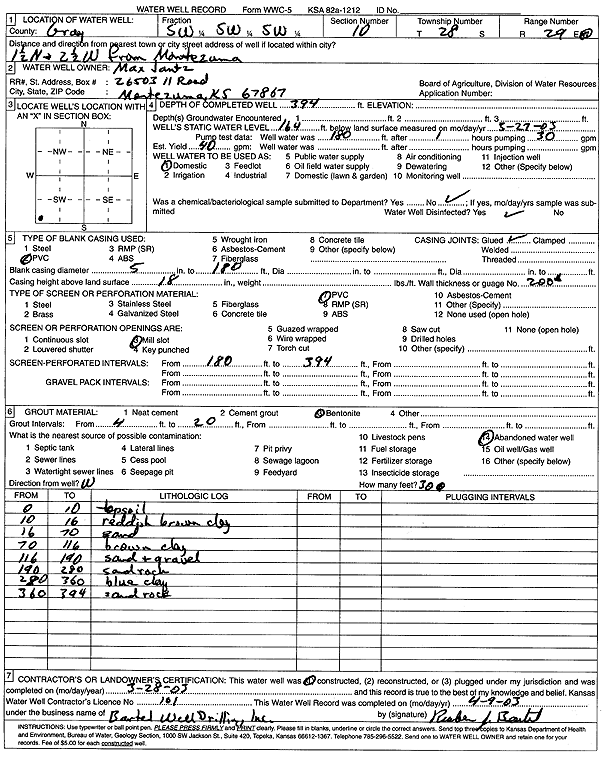
Specific Water Well Detail |
|
|
| Location Info | |||
| Owner: Jantz, Max | Status: Constructed | ||
| Location: T28S, R29W, Sec. 10, SW SW SW | County: Gray | ||
| Directions: from Montezuma: 1.5 mi N, 2.5 mi W | |||
| Latitude: 37.6212547 | Longitude: -100.4869754 | Datum NAD 27 | |
| Latitude: 37.6212778 | Longitude: -100.4874038 | Datum NAD 83 | |
| Longitude and latitude calculated by Survey from township-range-section-quarter calls. Only good to within the quarter call accuracy. | |||
| View well on interactive map | |||
| General Info | ||
| Well Depth: 394 ft. | Elevation: ft. | |
| Static Water Level: 164 ft. | Est. Yield: 40 gpm. | |
| Comp. Date: 28-Mar-2003 | Well Use: Domestic | |
| DWR Applic. #: | Other ID: | |
| Driller Info | ||
| Driller: Bartel Well Drilling, Inc. | License #: 101 | |
| Scanned Form | View scan |
|
Chemical Sample Submitted?:
Water Well disinfected?: | ||
| Casing Info | ||
| Casing Type:
Casing Joints: |
Diam: in. to ft | |
| Casing height above land surface: in
Casing Weight: lbs/ft Wall thickness or gauge no.: | ||
| Screen and Perforation Info | ||
| Screen Type: | Screen Openings: | |
| Screen-perforated intervals | From: ft to ft | |
| Gravel pack intervals | From: ft to ft | |
| Grout Info | ||
| Grout used: | From: to ft | |
| Source of Possible Contamination | ||
| Source: | ||
| Direction from well: | Distance: ft | |
| Lithologic Log
(Log data entered by KGS.) | ||
| From: 0 ft. to 10 ft. | topsoil | |
| From: 10 ft. to 16 ft. | reddish brown clay | |
| From: 16 ft. to 70 ft. | sand | |
| From: 70 ft. to 116 ft. | brown clay | |
| From: 116 ft. to 190 ft. | sand and gravel | |
| From: 190 ft. to 280 ft. | sand rock | |
| From: 280 ft. to 360 ft. | blue clay | |
| From: 360 ft. to 394 ft. | sand rock | |