|
|
|
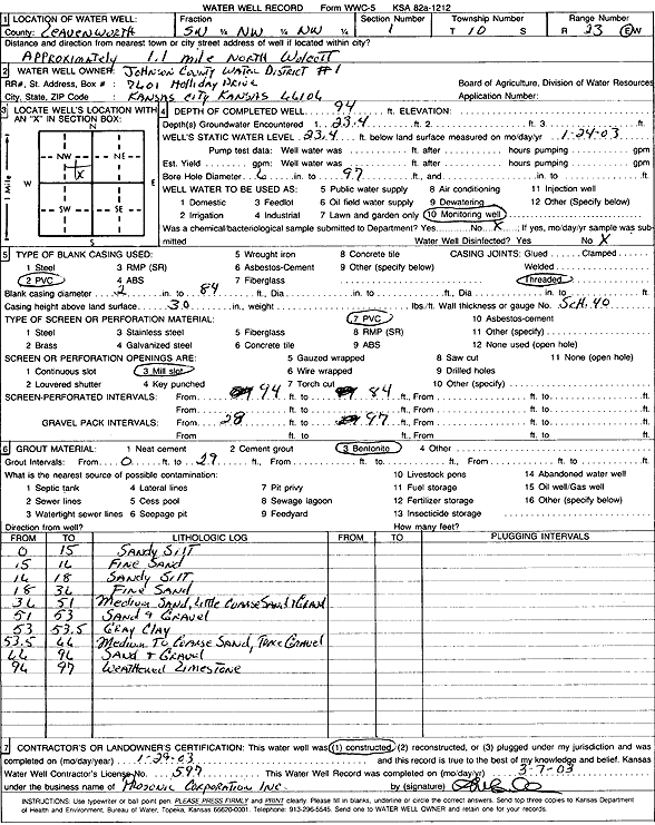
Specific Water Well Detail |
|
|
| Location Info | |||
| Owner: Johnson County Water District 1 | Status: Constructed | ||
| Location: T10S, R23E, Sec. 1, SW NW NW | County: Leavenworth | ||
| Directions: from Wolcott: 1.1 mi N | |||
| Latitude: 39.2128812 | Longitude: -94.8060982 | Datum NAD 27 | |
| Latitude: 39.2128835 | Longitude: -94.8063377 | Datum NAD 83 | |
| Longitude and latitude calculated by Survey from township-range-section-quarter calls. Only good to within the quarter call accuracy. | |||
| View well on interactive map | |||
| General Info | ||
| Well Depth: 94 ft. | Elevation: ft. | |
| Static Water Level: 23.4 ft. | Est. Yield: gpm. | |
| Comp. Date: 29-Jan-2003 | Well Use: Monitoring well/observation/piezometer | |
| DWR Applic. #: | Other ID: | |
| Driller Info | ||
| Driller: Prosonic Corporation Inc | License #: 597 | |
| Scanned Form | View scan |
|
Chemical Sample Submitted?:
Water Well disinfected?: | ||
| Casing Info | ||
| Casing Type:
Casing Joints: |
Diam: in. to ft | |
| Casing height above land surface: in
Casing Weight: lbs/ft Wall thickness or gauge no.: | ||
| Screen and Perforation Info | ||
| Screen Type: | Screen Openings: | |
| Screen-perforated intervals | From: ft to ft | |
| Gravel pack intervals | From: ft to ft | |
| Grout Info | ||
| Grout used: | From: to ft | |
| Source of Possible Contamination | ||
| Source: | ||
| Direction from well: | Distance: ft | |
| Lithologic Log
(Log data entered by KGS.) | ||
| From: 0 ft. to 15 ft. | sandy silt | |
| From: 15 ft. to 16 ft. | fine sand | |
| From: 16 ft. to 18 ft. | sandy silt | |
| From: 18 ft. to 36 ft. | fine sand | |
| From: 36 ft. to 51 ft. | medium sand with little coarse sand and gravel | |
| From: 51 ft. to 53 ft. | sand and gravel | |
| From: 53 ft. to 53.5 ft. | gray clay | |
| From: 53.5 ft. to 66 ft. | medium to coarse sand with trace gravel | |
| From: 66 ft. to 96 ft. | sand and gravel | |
| From: 96 ft. to 97 ft. | weathered limestone | |