|
|
|
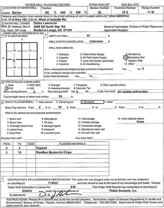
Specific Water Well Detail |
|
|
| Location Info | |||
| Owner: Lawrence, Dallas | Status: Plugged | ||
| Location: T31S, R11W, Sec. 30, NE NW SW | County: Barber | ||
| Directions: 3 mi N of Hwy 160, .8 mi W of Isabelle Rd | |||
| Latitude: 37.3183893 | Longitude: -98.564738 | Datum NAD 27 | |
| Latitude: 37.3184114 | Longitude: -98.5650986 | Datum NAD 83 | |
| Longitude and latitude calculated by Survey from township-range-section-quarter calls. Only good to within the quarter call accuracy. | |||
| View well on interactive map | |||
| General Info | ||
| Well Depth: 15 ft. | Elevation: ft. | |
| Static Water Level: ft. | Est. Yield: gpm. | |
| Comp. Date: 06-Nov-2002 | Well Use: Monitoring well/observation/piezometer | |
| DWR Applic. #: | Other ID: Well 2000702 | |
| Driller Info | ||
| Driller: Dennis J. Anderson, Thiele Geotech, Inc. | License #: 616 | |
| Scanned Form | View scan |
| Casing Info | ||
|
Casing Type:
Diam: in. Casing height above land surface: in | ||
| Grout Info | ||
| Grout used: | From: to ft | |
| Source of Possible Contamination | ||
| Source: | ||
| Direction from well: | Distance: ft | |