|
|
|
Specific Water Well Detail |
|
|
| Location Info | |||
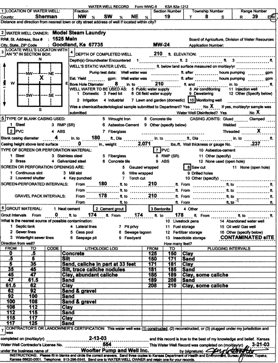
| Owner: Model Steam Laundry | Status: Constructed | ||
| Location: T8S, R39W, Sec. 19, NW SW NE | County: Sherman | ||
| Directions: | |||
| Latitude: 39.3466589 | Longitude: -101.7150665 | Datum NAD 27 | |
| Latitude: 39.3466586 | Longitude: -101.7155167 | Datum NAD 83 | |
| Longitude and latitude calculated by Survey from township-range-section-quarter calls. Only good to within the quarter call accuracy. | |||
| View well on interactive map | |||
| General Info | ||
| Well Depth: 210 ft. | Elevation: ft. | |
| Static Water Level: ft. | Est. Yield: gpm. | |
| Comp. Date: 13-Feb-2003 | Well Use: Monitoring well/observation/piezometer | |
| DWR Applic. #: | Other ID: MW 24 | |
| Driller Info | ||
| Driller: Jay C. Woofter Pump & Well, Inc. | License #: 554 | |
| Scanned Form | View scan |
|
Chemical Sample Submitted?:
Water Well disinfected?: | ||
| Casing Info | ||
| Casing Type:
Casing Joints: |
Diam: in. to ft | |
| Casing height above land surface: in
Casing Weight: lbs/ft Wall thickness or gauge no.: | ||
| Screen and Perforation Info | ||
| Screen Type: | Screen Openings: | |
| Screen-perforated intervals | From: ft to ft | |
| Gravel pack intervals | From: ft to ft | |
| Grout Info | ||
| Grout used: | From: to ft | |
| Source of Possible Contamination | ||
| Source: | ||
| Direction from well: | Distance: ft | |
| Lithologic Log
(Log data entered by KGS.) | ||
| From: 0 ft. to .5 ft. | Concrete | |
| From: .5 ft. to 5 ft. | Silt | |
| From: 5 ft. to 35 ft. | Sand, caliche in part at 33 feet | |
| From: 35 ft. to 45 ft. | Silt, trace caliche nodules | |
| From: 45 ft. to 47 ft. | Clay, abundant caliche | |
| From: 47 ft. to 61.5 ft. | Sand | |
| From: 61.5 ft. to 62 ft. | Clay | |
| From: 62 ft. to 92 ft. | Sand and gravel | |
| From: 92 ft. to 100 ft. | Sand | |
| From: 100 ft. to 108 ft. | Sand and gravel | |
| From: 108 ft. to 112 ft. | Clay | |
| From: 112 ft. to 115 ft. | Sand | |
| From: 115 ft. to 117 ft. | Clay | |
| From: 117 ft. to 125 ft. | Sand | |
| From: 125 ft. to 150 ft. | Clay | |
| From: 150 ft. to 171 ft. | Sand | |
| From: 171 ft. to 181 ft. | Clay | |
| From: 181 ft. to 185 ft. | Sand | |
| From: 185 ft. to 189 ft. | Clay, some caliche | |
| From: 189 ft. to 208 ft. | Sand | |
| From: 208 ft. to 210 ft. | Clay, some caliche | |