|
|
|
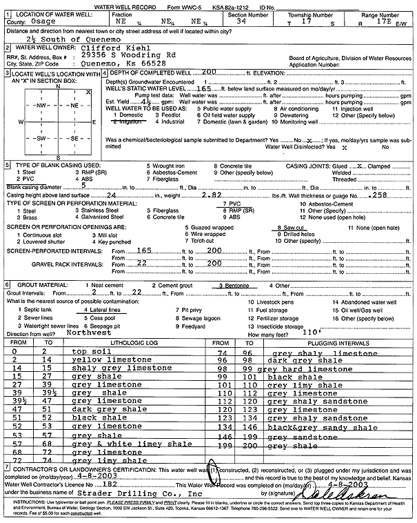
Specific Water Well Detail |
|
|
| Location Info | |||
| Owner: Kiehl, Clifford | Status: Constructed | ||
| Location: T17S, R17E, Sec. 34, NE NE NE | County: Osage | ||
| Directions: from Quenemo: 2.5 mi S | |||
| Latitude: 38.5351256 | Longitude: -95.5094774 | Datum NAD 27 | |
| Latitude: 38.5351379 | Longitude: -95.5097361 | Datum NAD 83 | |
| Longitude and latitude calculated by Survey from township-range-section-quarter calls. Only good to within the quarter call accuracy. | |||
| View well on interactive map | |||
| General Info | ||
| Well Depth: 200 ft. | Elevation: ft. | |
| Static Water Level: 165 ft. | Est. Yield: 4.5 gpm. | |
| Comp. Date: 08-Apr-2003 | Well Use: Domestic | |
| DWR Applic. #: | Other ID: | |
| Driller Info | ||
| Driller: Strader Drilling Co., Inc. | License #: 182 | |
| Scanned Form | View scan |
|
Chemical Sample Submitted?:
Water Well disinfected?: | ||
| Casing Info | ||
| Casing Type:
Casing Joints: |
Diam: in. to ft | |
| Casing height above land surface: in
Casing Weight: lbs/ft Wall thickness or gauge no.: | ||
| Screen and Perforation Info | ||
| Screen Type: | Screen Openings: | |
| Screen-perforated intervals | From: ft to ft | |
| Gravel pack intervals | From: ft to ft | |
| Grout Info | ||
| Grout used: | From: to ft | |
| Source of Possible Contamination | ||
| Source: | ||
| Direction from well: | Distance: ft | |
| Lithologic Log
(Log data entered by KGS.) | ||
| From: 0 ft. to 2 ft. | top soil | |
| From: 2 ft. to 14 ft. | yellow limestone | |
| From: 14 ft. to 15 ft. | shaley gray limestone | |
| From: 15 ft. to 27 ft. | gray shale | |
| From: 27 ft. to 39 ft. | gray limestone | |
| From: 39 ft. to 39.5 ft. | gray shale | |
| From: 39.5 ft. to 47 ft. | gray limestone | |
| From: 47 ft. to 51 ft. | dark gray shale | |
| From: 51 ft. to 52 ft. | black shale | |
| From: 52 ft. to 53 ft. | gray limestone | |
| From: 53 ft. to 57 ft. | gray shale | |
| From: 57 ft. to 68 ft. | gray and white limey shale | |
| From: 68 ft. to 72 ft. | gray limestone | |
| From: 72 ft. to 74 ft. | gray limey shale | |
| From: 74 ft. to 96 ft. | gray shaley limestone | |
| From: 96 ft. to 98 ft. | dark gray shale | |
| From: 98 ft. to 99 ft. | gray hard limestone | |
| From: 99 ft. to 101 ft. | black shale | |
| From: 101 ft. to 110 ft. | gray limey shale | |
| From: 110 ft. to 112 ft. | gray limestone | |
| From: 112 ft. to 120 ft. | gray shaley sandstone | |
| From: 120 ft. to 123 ft. | gray limestone | |
| From: 123 ft. to 134 ft. | gray shaley limestone | |
| From: 134 ft. to 146 ft. | black and gray sandy shale | |
| From: 146 ft. to 199 ft. | gray sandstone | |
| From: 199 ft. to 200 ft. | gray shale | |