|
|
|
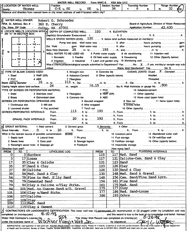
Specific Water Well Detail |
|
|
| Location Info | |||
| Owner: Schroeder, Robert D. | Status: Constructed | ||
| Location: T6S, R32W, Sec. 34, E2 SE SE | County: Thomas | ||
| Directions: | |||
| Latitude: 39.4832366 | Longitude: -100.8702105 | Datum NAD 27 | |
| Latitude: 39.48324 | Longitude: -100.8706395 | Datum NAD 83 | |
| Longitude and latitude calculated by Survey from township-range-section-quarter calls. Only good to within the quarter call accuracy. | |||
| View well on interactive map | |||
| General Info | ||
| Well Depth: 193 ft. | Elevation: ft. | |
| Static Water Level: 120 ft. | Est. Yield: gpm. | |
| Comp. Date: 10-Apr-1998 | Well Use: Irrigation | |
| DWR Applic. #: 42630 | Other ID: | |
| Links | |
| No Wizard information available. | |
| View info from WIMAS Water Right Data base... | |
| Driller Info | ||
| Driller: Jay C. Woofter Pump & Well, Inc. | License #: 554 | |
| Scanned Form | View scan |
|
Chemical Sample Submitted?:
Water Well disinfected?: | ||
| Casing Info | ||
| Casing Type:
Casing Joints: |
Diam: in. to ft | |
| Casing height above land surface: in
Casing Weight: lbs/ft Wall thickness or gauge no.: | ||
| Screen and Perforation Info | ||
| Screen Type: | Screen Openings: | |
| Screen-perforated intervals | From: ft to ft | |
| Gravel pack intervals | From: ft to ft | |
| Grout Info | ||
| Grout used: | From: to ft | |
| Source of Possible Contamination | ||
| Source: | ||
| Direction from well: | Distance: ft | |
| Lithologic Log
(Log data entered by KGS.) | ||
| From: 0 ft. to 3 ft. | Surface | |
| From: 3 ft. to 17 ft. | Loess | |
| From: 17 ft. to 35 ft. | Clay and caliche | |
| From: 35 ft. to 37 ft. | Sand and clay | |
| From: 37 ft. to 39 ft. | Caliche | |
| From: 39 ft. to 54 ft. | Medium sand and clay | |
| From: 54 ft. to 78 ft. | Cemented sand | |
| From: 78 ft. to 79 ft. | Fine to medium silty sand | |
| From: 79 ft. to 94 ft. | Clay and caliche with clay streaks | |
| From: 94 ft. to 101 ft. | Medium to coarse sand with small gravel | |
| From: 101 ft. to 106 ft. | Clay with sand streaks | |
| From: 106 ft. to 107 ft. | Caliche | |
| From: 107 ft. to 109 ft. | Clay | |
| From: 109 ft. to 112 ft. | Medium sand | |
| From: 112 ft. to 115 ft. | Clay and cement | |
| From: 115 ft. to 117 ft. | Medium sand | |
| From: 117 ft. to 121 ft. | Caliche, cemented sand and clay | |
| From: 121 ft. to 123 ft. | Sand | |
| From: 123 ft. to 126 ft. | Clay | |
| From: 126 ft. to 130 ft. | Sand and clay | |
| From: 130 ft. to 148 ft. | Medium sand and gravel | |
| From: 148 ft. to 156 ft. | Cemented sand with fine sand layers | |
| From: 156 ft. to 161 ft. | Fine sand | |
| From: 161 ft. to 175 ft. | Medium sand | |
| From: 175 ft. to 177 ft. | Clay | |
| From: 177 ft. to 186 ft. | Medium sand - loose | |
| From: 186 ft. to 193 ft. | Ochre | |