|
|
|
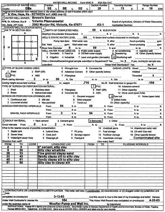
Specific Water Well Detail |
|
|
| Location Info | |||
| Owner: Brown's Service Center | Status: Constructed | ||
| Location: T13S, R18W, Sec. 28, SE SE SE | County: Ellis | ||
| Directions: 27th and Vine, Hays (btwn SV 1 and MW 12) | |||
| Latitude: 38.8864047 | Longitude: -99.3185741 | Datum NAD 27 | |
| Latitude: 38.8864163 | Longitude: -99.3189553 | Datum NAD 83 | |
| Longitude and latitude calculated by Survey from township-range-section-quarter calls. Only good to within the quarter call accuracy. | |||
| View well on interactive map | |||
| General Info | ||
| Well Depth: 58 ft. | Elevation: ft. | |
| Static Water Level: ft. | Est. Yield: gpm. | |
| Comp. Date: 13-Mar-2003 | Well Use: Monitoring well/observation/piezometer | |
| DWR Applic. #: | Other ID: AS 1 | |
| Driller Info | ||
| Driller: Jay C. Woofter Pump & Well, Inc. | License #: 554 | |
| Scanned Form | View scan |
|
Chemical Sample Submitted?:
Water Well disinfected?: | ||
| Casing Info | ||
| Casing Type:
Casing Joints: |
Diam: in. to ft | |
| Casing height above land surface: in
Casing Weight: lbs/ft Wall thickness or gauge no.: | ||
| Screen and Perforation Info | ||
| Screen Type: | Screen Openings: | |
| Screen-perforated intervals | From: ft to ft | |
| Gravel pack intervals | From: ft to ft | |
| Grout Info | ||
| Grout used: | From: to ft | |
| Source of Possible Contamination | ||
| Source: | ||
| Direction from well: | Distance: ft | |
| Lithologic Log
(Log data entered by KGS.) | ||
| From: 0 ft. to 5 ft. | 6-inch concrete, silty clay | |
| From: 5 ft. to 28 ft. | silty clay with caliche | |
| From: 28 ft. to 33 ft. | fine clayey sand | |
| From: 33 ft. to 40 ft. | sandy clayey silt to silty clay | |
| From: 40 ft. to 51 ft. | sandy clayey silt to silty clay | |
| From: 51 ft. to 58 ft. | silty clay to clayey silt | |