|
|
|
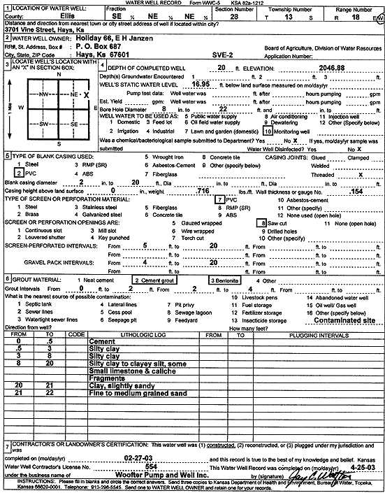
Specific Water Well Detail |
|
|
| Location Info | |||
| Owner: Holiday 66 | Status: Constructed | ||
| Location: T13S, R18W, Sec. 28, SE NE NE | County: Ellis | ||
| Directions: 3701 Vine St, Hays | |||
| Latitude: 38.8972963 | Longitude: -99.318434 | Datum NAD 27 | |
| Latitude: 38.8973078 | Longitude: -99.3188151 | Datum NAD 83 | |
| Longitude and latitude calculated by Survey from township-range-section-quarter calls. Only good to within the quarter call accuracy. | |||
| View well on interactive map | |||
| General Info | ||
| Well Depth: 20 ft. | Elevation: 2046.88 ft. | |
| Static Water Level: 16.95 ft. | Est. Yield: gpm. | |
| Comp. Date: 27-Feb-2003 | Well Use: Environmental Remediation, Soil Vapor Extraction | |
| DWR Applic. #: | Other ID: SVE 2 | |
| Driller Info | ||
| Driller: Jay C. Woofter Pump & Well, Inc. | License #: 554 | |
| Scanned Form | View scan |
|
Chemical Sample Submitted?:
Water Well disinfected?: | ||
| Casing Info | ||
| Casing Type:
Casing Joints: |
Diam: in. to ft | |
| Casing height above land surface: in
Casing Weight: lbs/ft Wall thickness or gauge no.: | ||
| Screen and Perforation Info | ||
| Screen Type: | Screen Openings: | |
| Screen-perforated intervals | From: ft to ft | |
| Gravel pack intervals | From: ft to ft | |
| Grout Info | ||
| Grout used: | From: to ft | |
| Source of Possible Contamination | ||
| Source: | ||
| Direction from well: | Distance: ft | |
| Lithologic Log
(Log data entered by KGS.) | ||
| From: 0 ft. to .5 ft. | concrete | |
| From: .5 ft. to 3 ft. | silty clay | |
| From: 3 ft. to 8 ft. | silty clay | |
| From: 8 ft. to 20 ft. | silty clay to clayey silt, some small limestone, and caliche fragments | |
| From: 20 ft. to 21 ft. | clay, slightly sandy | |
| From: 21 ft. to 22 ft. | fine to medium sand | |