|
|
|
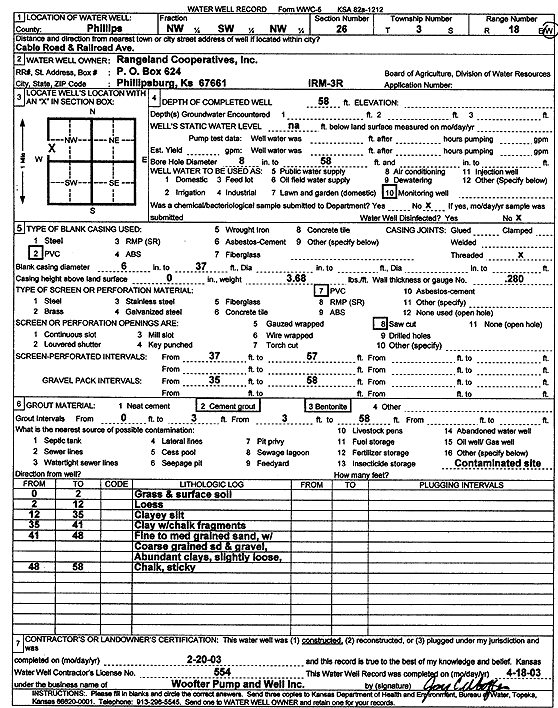
Specific Water Well Detail |
|
|
| Location Info | |||
| Owner: Rangeland Cooperatives, Inc. | Status: Constructed | ||
| Location: T3S, R18W, Sec. 26, NW SW NW | County: Phillips | ||
| Directions: Cable Road and Railroad Ave, Phillipsburg | |||
| Latitude: 39.7657274 | Longitude: -99.3265903 | Datum NAD 27 | |
| Latitude: 39.7657371 | Longitude: -99.3269647 | Datum NAD 83 | |
| Longitude and latitude calculated by Survey from township-range-section-quarter calls. Only good to within the quarter call accuracy. | |||
| View well on interactive map | |||
| General Info | ||
| Well Depth: 58 ft. | Elevation: ft. | |
| Static Water Level: ft. | Est. Yield: gpm. | |
| Comp. Date: 20-Feb-2003 | Well Use: Monitoring well/observation/piezometer | |
| DWR Applic. #: | Other ID: IRM 3R | |
| Driller Info | ||
| Driller: Jay C. Woofter Pump & Well, Inc. | License #: 554 | |
| Scanned Form | View scan |
|
Chemical Sample Submitted?:
Water Well disinfected?: | ||
| Casing Info | ||
| Casing Type:
Casing Joints: |
Diam: in. to ft | |
| Casing height above land surface: in
Casing Weight: lbs/ft Wall thickness or gauge no.: | ||
| Screen and Perforation Info | ||
| Screen Type: | Screen Openings: | |
| Screen-perforated intervals | From: ft to ft | |
| Gravel pack intervals | From: ft to ft | |
| Grout Info | ||
| Grout used: | From: to ft | |
| Source of Possible Contamination | ||
| Source: | ||
| Direction from well: | Distance: ft | |
| Lithologic Log
(Log data entered by KGS.) | ||
| From: 0 ft. to 2 ft. | grass and surface soil | |
| From: 2 ft. to 12 ft. | loess | |
| From: 12 ft. to 35 ft. | clayey silt | |
| From: 35 ft. to 41 ft. | clay with chalk fragments | |
| From: 41 ft. to 48 ft. | fine to medium grained sand with coarse grained sand and gravel, abundant clays, slightly loose | |
| From: 48 ft. to 58 ft. | chalk, sticky | |