|
|
|
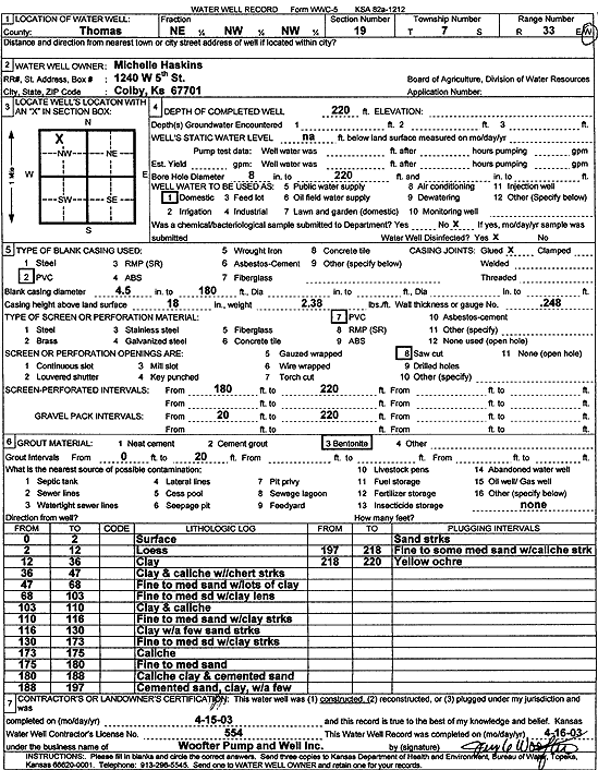
Specific Water Well Detail |
|
|
| Location Info | |||
| Owner: Michelle Haskins | Status: Constructed | ||
| Location: T7S, R33W, Sec. 19, NE NW NW | County: Thomas | ||
| Directions: | |||
| Latitude: 39.4367953 | Longitude: -101.0505551 | Datum NAD 27 | |
| Latitude: 39.4367984 | Longitude: -101.0509884 | Datum NAD 83 | |
| Longitude and latitude calculated by Survey from township-range-section-quarter calls. Only good to within the quarter call accuracy. | |||
| View well on interactive map | |||
| General Info | ||
| Well Depth: 220 ft. | Elevation: ft. | |
| Static Water Level: ft. | Est. Yield: gpm. | |
| Comp. Date: 15-Apr-2003 | Well Use: Domestic | |
| DWR Applic. #: | Other ID: | |
| Driller Info | ||
| Driller: Jay C. Woofter Pump & Well, Inc. | License #: 554 | |
| Scanned Form | View scan |
|
Chemical Sample Submitted?:
Water Well disinfected?: | ||
| Casing Info | ||
| Casing Type:
Casing Joints: |
Diam: in. to ft | |
| Casing height above land surface: in
Casing Weight: lbs/ft Wall thickness or gauge no.: | ||
| Screen and Perforation Info | ||
| Screen Type: | Screen Openings: | |
| Screen-perforated intervals | From: ft to ft | |
| Gravel pack intervals | From: ft to ft | |
| Grout Info | ||
| Grout used: | From: to ft | |
| Source of Possible Contamination | ||
| Source: | ||
| Direction from well: | Distance: ft | |
| Lithologic Log
(Log data entered by KGS.) | ||
| From: 0 ft. to 2 ft. | Surface | |
| From: 2 ft. to 12 ft. | Loess | |
| From: 12 ft. to 36 ft. | Clay | |
| From: 36 ft. to 47 ft. | Clay and caliche with chert streaks | |
| From: 47 ft. to 68 ft. | Fine to medium sand with lots of clay | |
| From: 68 ft. to 103 ft. | Fine to medium sand with clay lens | |
| From: 103 ft. to 110 ft. | Clay and caliche | |
| From: 110 ft. to 116 ft. | Fine to medium sand with clay streaks | |
| From: 116 ft. to 130 ft. | Clay with a few sand streaks | |
| From: 130 ft. to 173 ft. | Fine to medium sand with clay streaks | |
| From: 173 ft. to 175 ft. | Caliche | |
| From: 175 ft. to 180 ft. | Fine to medium sand | |
| From: 180 ft. to 188 ft. | Caliche clay and cemented sand | |
| From: 188 ft. to 197 ft. | Cemented sand, clay with a few sand streaks | |
| From: 197 ft. to 218 ft. | Fine to some medium sand with caliche streak | |
| From: 218 ft. to 220 ft. | Yellow ochre | |