|
|
|
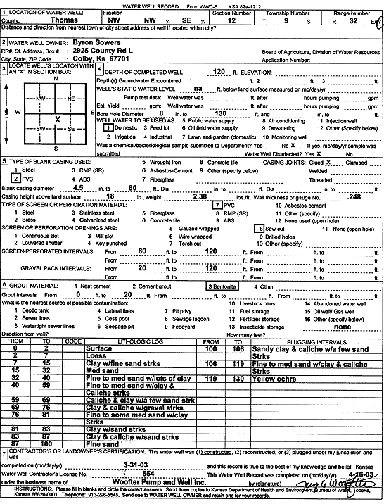
Specific Water Well Detail |
|
|
| Location Info | |||
| Owner: Sowers, Byron | Status: Constructed | ||
| Location: T9S, R32W, Sec. 12, NW NW SE | County: Thomas | ||
| Directions: | |||
| Latitude: 39.2844347 | Longitude: -100.8413297 | Datum NAD 27 | |
| Latitude: 39.2844403 | Longitude: -100.8417571 | Datum NAD 83 | |
| Longitude and latitude calculated by Survey from township-range-section-quarter calls. Only good to within the quarter call accuracy. | |||
| View well on interactive map | |||
| General Info | ||
| Well Depth: 120 ft. | Elevation: ft. | |
| Static Water Level: ft. | Est. Yield: gpm. | |
| Comp. Date: 31-Mar-2003 | Well Use: Domestic | |
| DWR Applic. #: | Other ID: | |
| Driller Info | ||
| Driller: Jay C. Woofter Pump & Well, Inc. | License #: 554 | |
| Scanned Form | View scan |
|
Chemical Sample Submitted?:
Water Well disinfected?: | ||
| Casing Info | ||
| Casing Type:
Casing Joints: |
Diam: in. to ft | |
| Casing height above land surface: in
Casing Weight: lbs/ft Wall thickness or gauge no.: | ||
| Screen and Perforation Info | ||
| Screen Type: | Screen Openings: | |
| Screen-perforated intervals | From: ft to ft | |
| Gravel pack intervals | From: ft to ft | |
| Grout Info | ||
| Grout used: | From: to ft | |
| Source of Possible Contamination | ||
| Source: | ||
| Direction from well: | Distance: ft | |
| Lithologic Log
(Log data entered by KGS.) | ||
| From: 0 ft. to 2 ft. | surface | |
| From: 2 ft. to 7 ft. | loess | |
| From: 7 ft. to 15 ft. | clay with fine sand streaks | |
| From: 15 ft. to 32 ft. | medium sand | |
| From: 32 ft. to 40 ft. | fine to medium sand with lots of clay | |
| From: 40 ft. to 59 ft. | fine to medium sand with clay and caliche streaks | |
| From: 59 ft. to 69 ft. | caliche and clay with a few sand streak | |
| From: 69 ft. to 76 ft. | clay and caliche with gravel streaks | |
| From: 76 ft. to 81 ft. | fine to some medium sand with clay streaks | |
| From: 81 ft. to 83 ft. | clay with sand streaks | |
| From: 83 ft. to 87 ft. | clay and caliche with sand streaks | |
| From: 87 ft. to 100 ft. | fine sand | |
| From: 100 ft. to 106 ft. | sandy clay and caliche with a few sand streaks | |
| From: 106 ft. to 119 ft. | fine to medium sand with clay and caliche streaks | |
| From: 119 ft. to 130 ft. | yellow ochre | |