|
|
|
Specific Water Well Detail |
|
|
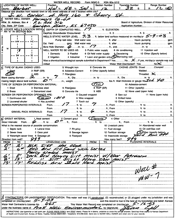
| Location Info | |||
| Owner: Farmers Co-op | Status: Constructed | ||
| Location: T32S, R12W, Sec. 12, NW NE SW | County: Barber | ||
| Directions: SW corner of Hwy 160 and Cherry St, Medicine Lodge | |||
| Latitude: 37.274912 | Longitude: -98.5808002 | Datum NAD 27 | |
| Latitude: 37.2749349 | Longitude: -98.5811613 | Datum NAD 83 | |
| Longitude and latitude calculated by Survey from township-range-section-quarter calls. Only good to within the quarter call accuracy. | |||
| View well on interactive map | |||
| General Info | ||
| Well Depth: 17 ft. | Elevation: ft. | |
| Static Water Level: 7.3 ft. | Est. Yield: gpm. | |
| Comp. Date: 09-May-2003 | Well Use: Monitoring well/observation/piezometer | |
| DWR Applic. #: | Other ID: MW 7 | |
| Driller Info | ||
| Driller: Pratt Well Service, Inc. | License #: 665 | |
| Scanned Form | View scan |
|
Chemical Sample Submitted?:
Water Well disinfected?: | ||
| Casing Info | ||
| Casing Type:
Casing Joints: |
Diam: in. to ft | |
| Casing height above land surface: in
Casing Weight: lbs/ft Wall thickness or gauge no.: | ||
| Screen and Perforation Info | ||
| Screen Type: | Screen Openings: | |
| Screen-perforated intervals | From: ft to ft | |
| Gravel pack intervals | From: ft to ft | |
| Grout Info | ||
| Grout used: | From: to ft | |
| Source of Possible Contamination | ||
| Source: | ||
| Direction from well: | Distance: ft | |
| Lithologic Log
(Log data entered by KGS.) | ||
| From: 0 ft. to 2 ft. | black silt, odor | |
| From: 2 ft. to 6 ft. | red brown fill sand, well sorted, poorly graded, moist | |
| From: 6 ft. to 8 ft. | dark brown clayey silt, moist, with petroleum odor | |
| From: 8 ft. to 13 ft. | dark brown silt, slight petroleum odor, moist | |
| From: 13 ft. to 17 ft. | reddish brown shale, hard, moist | |