|
|
|
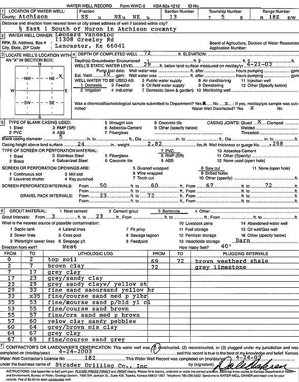
Specific Water Well Detail |
|
|
| Location Info | |||
| Owner: Vanderloo, Leonard | Status: Constructed | ||
| Location: T5S, R18E, Sec. 13, SE NE NE | County: Atchison | ||
| Directions: from Huron: .5 mi E, 1 mi S | |||
| Latitude: 39.6211198 | Longitude: -95.340669 | Datum NAD 27 | |
| Latitude: 39.6211191 | Longitude: -95.340922 | Datum NAD 83 | |
| Longitude and latitude calculated by Survey from township-range-section-quarter calls. Only good to within the quarter call accuracy. | |||
| View well on interactive map | |||
| General Info | ||
| Well Depth: 72 ft. | Elevation: ft. | |
| Static Water Level: 29 ft. | Est. Yield: 10 gpm. | |
| Comp. Date: 24-Apr-2003 | Well Use: Domestic | |
| DWR Applic. #: | Other ID: | |
| Driller Info | ||
| Driller: Strader Drilling Co., Inc. | License #: 182 | |
| Scanned Form | View scan |
|
Chemical Sample Submitted?:
Water Well disinfected?: | ||
| Casing Info | ||
| Casing Type:
Casing Joints: |
Diam: in. to ft | |
| Casing height above land surface: in
Casing Weight: lbs/ft Wall thickness or gauge no.: | ||
| Screen and Perforation Info | ||
| Screen Type: | Screen Openings: | |
| Screen-perforated intervals | From: ft to ft | |
| Gravel pack intervals | From: ft to ft | |
| Grout Info | ||
| Grout used: | From: to ft | |
| Source of Possible Contamination | ||
| Source: | ||
| Direction from well: | Distance: ft | |
| Lithologic Log
(Log data entered by KGS.) | ||
| From: 0 ft. to 2 ft. | Topsoil | |
| From: 2 ft. to 7 ft. | Clay, brown | |
| From: 7 ft. to 17 ft. | Clay, gray | |
| From: 17 ft. to 23 ft. | Sandy clay, gray | |
| From: 23 ft. to 29 ft. | Sandy clay, gray, with yellow streaks | |
| From: 29 ft. to 33 ft. | Fine sand, coarse sand, yellow brown | |
| From: 33 ft. to 35 ft. | Fine/coarse sand, medium pea, yellow brown | |
| From: 35 ft. to 53 ft. | Fine/coarse sand, pea/boulders, yellow clay | |
| From: 53 ft. to 55 ft. | Fine/coarse sand, brown | |
| From: 55 ft. to 57 ft. | Fine/coarse sand, medium pea, brown | |
| From: 57 ft. to 60 ft. | Yellow clay, sandy, pebbles | |
| From: 60 ft. to 64 ft. | Gray/brown mis clay | |
| From: 64 ft. to 67 ft. | Clay, gray | |
| From: 67 ft. to 69 ft. | Fine/coarse sand, gray | |
| From: 69 ft. to 72 ft. | Weathered shale, brown | |
| From: 72 ft. to ft. | Limestone, gray | |