|
|
|
Specific Water Well Detail |
|
|
| Location Info | |||
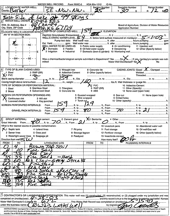
| Owner: Ellis, Richard | Status: Constructed | ||
| Location: T30S, R12W, Sec. 25, SE NW NW | County: Barber | ||
| Directions: E side of Lake at 99 Springs | |||
| Latitude: 37.4103385 | Longitude: -98.5889048 | Datum NAD 27 | |
| Latitude: 37.4103592 | Longitude: -98.5892671 | Datum NAD 83 | |
| Longitude and latitude calculated by Survey from township-range-section-quarter calls. Only good to within the quarter call accuracy. | |||
| View well on interactive map | |||
| General Info | ||
| Well Depth: 159 ft. | Elevation: ft. | |
| Static Water Level: 54 ft. | Est. Yield: gpm. | |
| Comp. Date: 28-Apr-2003 | Well Use: Domestic | |
| DWR Applic. #: | Other ID: | |
| Driller Info | ||
| Driller: Crowdis Water Well Service, LLC | License #: 672 | |
| Scanned Form | View scan |
|
Chemical Sample Submitted?:
Water Well disinfected?: | ||
| Casing Info | ||
| Casing Type:
Casing Joints: |
Diam: in. to ft | |
| Casing height above land surface: in
Casing Weight: lbs/ft Wall thickness or gauge no.: | ||
| Screen and Perforation Info | ||
| Screen Type: | Screen Openings: | |
| Screen-perforated intervals | From: ft to ft | |
| Gravel pack intervals | From: ft to ft | |
| Grout Info | ||
| Grout used: | From: to ft | |
| Source of Possible Contamination | ||
| Source: | ||
| Direction from well: | Distance: ft | |
| Lithologic Log
(Log data entered by KGS.) | ||
| From: 0 ft. to 4 ft. | brown top soil | |
| From: 4 ft. to 10 ft. | fine sand | |
| From: 10 ft. to 35 ft. | red clay | |
| From: 35 ft. to 55 ft. | fine sand, hard | |
| From: 55 ft. to 60 ft. | red clay with gray streaks | |
| From: 60 ft. to 63 ft. | fine sand | |
| From: 63 ft. to 65 ft. | red clay | |
| From: 65 ft. to 80 ft. | red clay with sand streaks | |
| From: 80 ft. to 95 ft. | fine sand with red clay streaks | |
| From: 95 ft. to 130 ft. | fine sand, tight, hard | |
| From: 130 ft. to 135 ft. | red shale | |
| From: 135 ft. to 159 ft. | fine sand | |