|
|
|
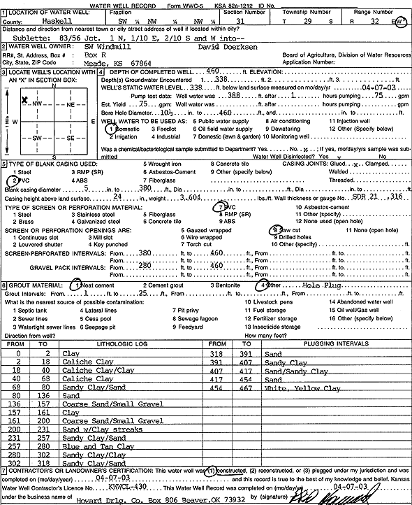
Specific Water Well Detail |
|
|
| Location Info | |||
| Owner: SW Windmill/David Doerksen | Status: Constructed | ||
| Location: T29S, R32W, Sec. 31, SW NW NW | County: Haskell | ||
| Directions: from Jct. 83 and 56, Sublette: 1 mi N, 0.1 mi E, 0.2 mi S, and W into site | |||
| Latitude: 37.4867593 | Longitude: -100.8694779 | Datum NAD 27 | |
| Latitude: 37.4867838 | Longitude: -100.8699192 | Datum NAD 83 | |
| Longitude and latitude calculated by Survey from township-range-section-quarter calls. Only good to within the quarter call accuracy. | |||
| View well on interactive map | |||
| General Info | ||
| Well Depth: 460 ft. | Elevation: ft. | |
| Static Water Level: 338 ft. | Est. Yield: 75 gpm. | |
| Comp. Date: 07-Apr-2003 | Well Use: Domestic | |
| DWR Applic. #: | Other ID: | |
| Driller Info | ||
| Driller: Howard Drilling Company AG, LLC | License #: 430 | |
| Scanned Form | View scan |
|
Chemical Sample Submitted?:
Water Well disinfected?: | ||
| Casing Info | ||
| Casing Type:
Casing Joints: |
Diam: in. to ft | |
| Casing height above land surface: in
Casing Weight: lbs/ft Wall thickness or gauge no.: | ||
| Screen and Perforation Info | ||
| Screen Type: | Screen Openings: | |
| Screen-perforated intervals | From: ft to ft | |
| Gravel pack intervals | From: ft to ft | |
| Grout Info | ||
| Grout used: | From: to ft | |
| Source of Possible Contamination | ||
| Source: | ||
| Direction from well: | Distance: ft | |
| Lithologic Log
(Log data entered by KGS.) | ||
| From: 0 ft. to 2 ft. | clay | |
| From: 2 ft. to 18 ft. | caliche clay | |
| From: 18 ft. to 40 ft. | caliche clay/clay | |
| From: 40 ft. to 68 ft. | caliche clay | |
| From: 68 ft. to 80 ft. | sandy clay/sand | |
| From: 80 ft. to 136 ft. | sand | |
| From: 136 ft. to 157 ft. | coarse sand/small gravel | |
| From: 157 ft. to 161 ft. | clay | |
| From: 161 ft. to 200 ft. | coarse sand/small gravel | |
| From: 200 ft. to 231 ft. | sand with clay streaks | |
| From: 231 ft. to 257 ft. | sandy clay/sand | |
| From: 257 ft. to 280 ft. | blue and tan clay | |
| From: 280 ft. to 302 ft. | sandy clay/clay | |
| From: 302 ft. to 318 ft. | sandy clay/sand | |
| From: 318 ft. to 391 ft. | sand | |
| From: 391 ft. to 407 ft. | sandy clay | |
| From: 407 ft. to 417 ft. | sand/sandy clay | |
| From: 417 ft. to 454 ft. | sand | |
| From: 454 ft. to 467 ft. | white, yellow clay | |