|
|
|
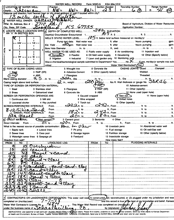
Specific Water Well Detail |
|
|
| Location Info | |||
| Owner: Gattshall, Wallace | Status: Constructed | ||
| Location: T6S, R41W, Sec. 23, NW NW NW | County: Sherman | ||
| Directions: from Ruleton, 13 mi N | |||
| Latitude: 39.5239141 | Longitude: -101.8717036 | Datum NAD 27 | |
| Latitude: 39.5239097 | Longitude: -101.872159 | Datum NAD 83 | |
| Longitude and latitude calculated by Survey from township-range-section-quarter calls. Only good to within the quarter call accuracy. | |||
| View well on interactive map | |||
| General Info | ||
| Well Depth: 242 ft. | Elevation: ft. | |
| Static Water Level: 105 ft. | Est. Yield: 20 gpm. | |
| Comp. Date: 07-Jul-1998 | Well Use: Domestic | |
| DWR Applic. #: | Other ID: | |
| Driller Info | ||
| Driller: Ruben T. Schaal Drilling Co. | License #: 484 | |
| Scanned Form | View scan |
|
Chemical Sample Submitted?:
Water Well disinfected?: | ||
| Casing Info | ||
| Casing Type:
Casing Joints: |
Diam: in. to ft | |
| Casing height above land surface: in
Casing Weight: lbs/ft Wall thickness or gauge no.: | ||
| Screen and Perforation Info | ||
| Screen Type: | Screen Openings: | |
| Screen-perforated intervals | From: ft to ft | |
| Gravel pack intervals | From: ft to ft | |
| Grout Info | ||
| Grout used: | From: to ft | |
| Source of Possible Contamination | ||
| Source: | ||
| Direction from well: | Distance: ft | |
| Lithologic Log
(Log data entered by KGS.) | ||
| From: 0 ft. to 10 ft. | Overburden | |
| From: 10 ft. to 20 ft. | Gravel | |
| From: 20 ft. to 42 ft. | Gravel and sand | |
| From: 42 ft. to 45 ft. | Rock | |
| From: 45 ft. to 65 ft. | Sand and clay | |
| From: 65 ft. to 85 ft. | Clay | |
| From: 85 ft. to 105 ft. | Sandstone, gravel, sand, and clay | |
| From: 105 ft. to 125 ft. | Sand and clay | |
| From: 125 ft. to 145 ft. | Gravel, sand, and clay | |
| From: 145 ft. to 185 ft. | Sand and clay | |
| From: 185 ft. to 205 ft. | Clay | |
| From: 205 ft. to 225 ft. | Gravel, sand, and clay | |
| From: 225 ft. to 240 ft. | Sand | |
| From: 240 ft. to 242 ft. | Shale | |