|
|
|
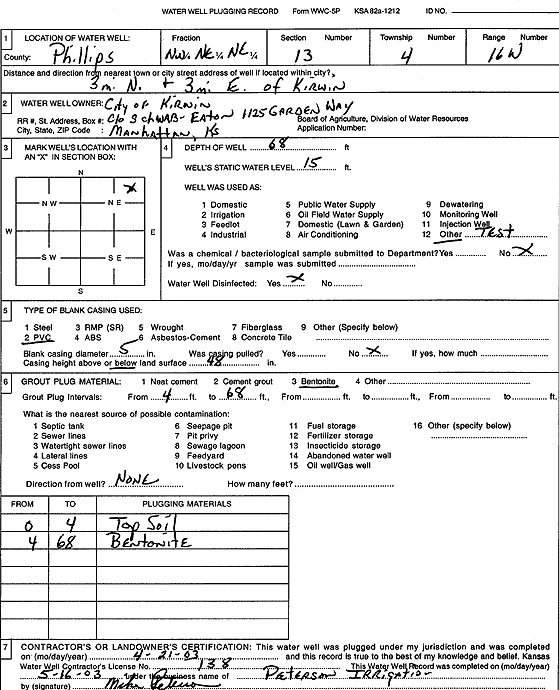
Specific Water Well Detail |
|
|
| Location Info | |||
| Owner: City of Kirwin | Status: Plugged | ||
| Location: T4S, R16W, Sec. 13, NW NE NE | County: Phillips | ||
| Directions: from Kirwin: 3 mi N, 3 mi E | |||
| Latitude: 39.7120762 | Longitude: -99.069509 | Datum NAD 27 | |
| Latitude: 39.7120871 | Longitude: -99.0698727 | Datum NAD 83 | |
| Longitude and latitude calculated by Survey from township-range-section-quarter calls. Only good to within the quarter call accuracy. | |||
| View well on interactive map | |||
| General Info | ||
| Well Depth: 68 ft. | Elevation: ft. | |
| Static Water Level: 15 ft. | Est. Yield: gpm. | |
| Comp. Date: 21-Apr-2003 | Well Use: Test hole/well | |
| DWR Applic. #: | Other ID: | |
| Driller Info | ||
| Driller: Michael Peterson Irrigation, Inc. | License #: 138 | |
| Scanned Form | View scan |
| Casing Info | ||
|
Casing Type:
Diam: in. Casing height above land surface: in | ||
| Grout Info | ||
| Grout used: | From: to ft | |
| Source of Possible Contamination | ||
| Source: | ||
| Direction from well: | Distance: ft | |