|
|
|
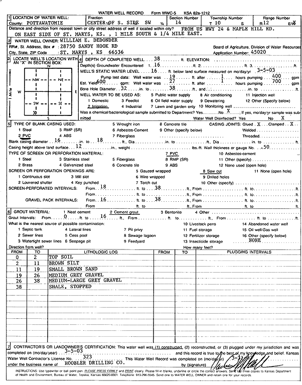
Specific Water Well Detail |
|
|
| Location Info | |||
| Owner: Dedonder, William E. | Status: Constructed | ||
| Location: T10S, R12E, Sec. 14, C S2 SW | County: Pottawatomie | ||
| Directions: from Hwy 24 and Maple Hill Rd, E side of St Marys: 1 mi S, .25 mi E | |||
| Latitude: 39.1750904 | Longitude: -96.0496894 | Datum NAD 27 | |
| Latitude: 39.1750881 | Longitude: -96.0499596 | Datum NAD 83 | |
| Longitude and latitude calculated by Survey from township-range-section-quarter calls. Only good to within the quarter call accuracy. | |||
| View well on interactive map | |||
| General Info | ||
| Well Depth: 38 ft. | Elevation: ft. | |
| Static Water Level: 16 ft. | Est. Yield: 600 gpm. | |
| Comp. Date: 05-Mar-2003 | Well Use: Irrigation | |
| DWR Applic. #: 45020 | Other ID: | |
| Links | |
| No Wizard information available. | |
| View info from WIMAS Water Right Data base... | |
| Driller Info | ||
| Driller: Daniel H. Hoobler Drilling Co. | License #: 323 | |
| Scanned Form | View scan |
|
Chemical Sample Submitted?:
Water Well disinfected?: | ||
| Casing Info | ||
| Casing Type:
Casing Joints: |
Diam: in. to ft | |
| Casing height above land surface: in
Casing Weight: lbs/ft Wall thickness or gauge no.: | ||
| Screen and Perforation Info | ||
| Screen Type: | Screen Openings: | |
| Screen-perforated intervals | From: ft to ft | |
| Gravel pack intervals | From: ft to ft | |
| Grout Info | ||
| Grout used: | From: to ft | |
| Source of Possible Contamination | ||
| Source: | ||
| Direction from well: | Distance: ft | |
| Lithologic Log
(Log data entered by KGS.) | ||
| From: 0 ft. to 2 ft. | top soil | |
| From: 2 ft. to 11 ft. | brown silt | |
| From: 11 ft. to 19 ft. | small brown sand | |
| From: 19 ft. to 26 ft. | medium gray gravel | |
| From: 26 ft. to 38 ft. | medium-large gray gravel | |
| From: 38 ft. to ft. | shale | |