|
|
|
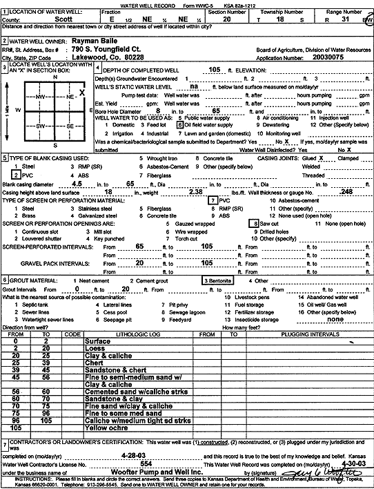
Specific Water Well Detail |
|
|
| Location Info | |||
| Owner: BaIile, Rayman | Status: Constructed | ||
| Location: T18S, R31W, Sec. 20, E NE NE | County: Scott | ||
| Directions: | |||
| Latitude: 38.4810411 | Longitude: -100.7616816 | Datum NAD 27 | |
| Latitude: 38.4810593 | Longitude: -100.7621077 | Datum NAD 83 | |
| Longitude and latitude calculated by Survey from township-range-section-quarter calls. Only good to within the quarter call accuracy. | |||
| View well on interactive map | |||
| General Info | ||
| Well Depth: 105 ft. | Elevation: ft. | |
| Static Water Level: ft. | Est. Yield: gpm. | |
| Comp. Date: 28-Apr-2003 | Well Use: Oil Field Water Supply | |
| DWR Applic. #: 20030075 | Other ID: | |
| Links | |
| No Wizard information available. | |
| View info from WIMAS Water Right Data base... | |
| Driller Info | ||
| Driller: Jay C. Woofter Pump & Well, Inc. | License #: 554 | |
| Scanned Form | View scan |
|
Chemical Sample Submitted?:
Water Well disinfected?: | ||
| Casing Info | ||
| Casing Type:
Casing Joints: |
Diam: in. to ft | |
| Casing height above land surface: in
Casing Weight: lbs/ft Wall thickness or gauge no.: | ||
| Screen and Perforation Info | ||
| Screen Type: | Screen Openings: | |
| Screen-perforated intervals | From: ft to ft | |
| Gravel pack intervals | From: ft to ft | |
| Grout Info | ||
| Grout used: | From: to ft | |
| Source of Possible Contamination | ||
| Source: | ||
| Direction from well: | Distance: ft | |
| Lithologic Log
(Log data entered by KGS.) | ||
| From: 0 ft. to 2 ft. | Surface | |
| From: 2 ft. to 20 ft. | Loess | |
| From: 20 ft. to 25 ft. | Clay and caliche | |
| From: 25 ft. to 39 ft. | Chert | |
| From: 39 ft. to 45 ft. | Sandstone and chert | |
| From: 45 ft. to 56 ft. | Fine to semi-medium sand with clay and caliche | |
| From: 56 ft. to 60 ft. | Cemented sand with caliche streaks | |
| From: 60 ft. to 70 ft. | Sandstone and clay | |
| From: 70 ft. to 75 ft. | Fine sand with clay and caliche | |
| From: 75 ft. to 96 ft. | Fine to some medium sand | |
| From: 96 ft. to 105 ft. | Caliche with medium tight sand streaks | |
| From: 105 ft. to ft. | Yellow ochre | |