|
|
|
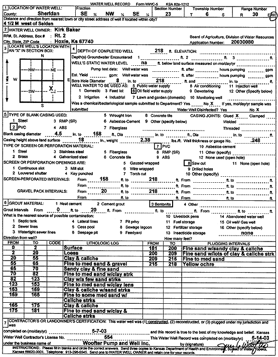
Specific Water Well Detail |
|
|
| Location Info | |||
| Owner: Baker, Kirk | Status: Constructed | ||
| Location: T6S, R30W, Sec. 23, SE NW SE | County: Sheridan | ||
| Directions: from Selden: 4.5 mi W | |||
| Latitude: 39.5143238 | Longitude: -100.6326194 | Datum NAD 27 | |
| Latitude: 39.5143277 | Longitude: -100.6330428 | Datum NAD 83 | |
| Longitude and latitude calculated by Survey from township-range-section-quarter calls. Only good to within the quarter call accuracy. | |||
| View well on interactive map | |||
| General Info | ||
| Well Depth: 218 ft. | Elevation: ft. | |
| Static Water Level: ft. | Est. Yield: gpm. | |
| Comp. Date: 07-May-2003 | Well Use: Oil Field Water Supply | |
| DWR Applic. #: 20030080 | Other ID: | |
| Links | |
| No Wizard information available. | |
| View info from WIMAS Water Right Data base... | |
| Driller Info | ||
| Driller: Woofter Pump & Well, Inc. | License #: 554 | |
| Scanned Form | View scan |
|
Chemical Sample Submitted?:
Water Well disinfected?: | ||
| Casing Info | ||
| Casing Type:
Casing Joints: |
Diam: in. to ft | |
| Casing height above land surface: in
Casing Weight: lbs/ft Wall thickness or gauge no.: | ||
| Screen and Perforation Info | ||
| Screen Type: | Screen Openings: | |
| Screen-perforated intervals | From: ft to ft | |
| Gravel pack intervals | From: ft to ft | |
| Grout Info | ||
| Grout used: | From: to ft | |
| Source of Possible Contamination | ||
| Source: | ||
| Direction from well: | Distance: ft | |
| Lithologic Log
(Log data entered by KGS.) | ||
| From: 0 ft. to 2 ft. | Surface | |
| From: 2 ft. to 20 ft. | Loess | |
| From: 20 ft. to 55 ft. | Clay and caliche | |
| From: 55 ft. to 65 ft. | Fine to medium sand and gravel | |
| From: 65 ft. to 70 ft. | Sandy clay and fine sand | |
| From: 70 ft. to 82 ft. | Fine to medium sand with clay streak | |
| From: 82 ft. to 123 ft. | Clay with a few sand streaks | |
| From: 123 ft. to 153 ft. | Fine to medium sand with clay lens | |
| From: 153 ft. to 159 ft. | Clay and caliche with sand streaks | |
| From: 159 ft. to 165 ft. | Fine to some medium sand with caliche streaks | |
| From: 165 ft. to 175 ft. | Clay and caliche | |
| From: 175 ft. to 181 ft. | Fine to medium sand with clay and caliche streaks | |
| From: 181 ft. to 200 ft. | Fine sand with sandy clay and caliche | |
| From: 200 ft. to 209 ft. | Fine sand with lots of clay and caliche streaks | |
| From: 209 ft. to 215 ft. | Fine to medium sand | |
| From: 215 ft. to 218 ft. | Yellow ochre | |