|
|
|
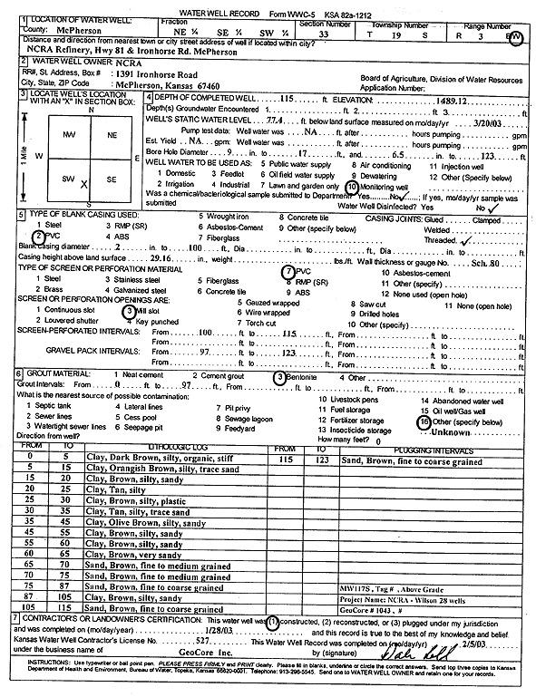
Specific Water Well Detail |
|
|
| Location Info | |||
| Owner: NCRA | Status: Constructed | ||
| Location: T19S, R3W, Sec. 33, NE SE SW | County: McPherson | ||
| Directions: NCRA Refinery, Hwy 81 and Ironhorse Rd, McPherson | |||
| Latitude: 38.350438 | Longitude: -97.6585322 | Datum NAD 27 | |
| Latitude: 38.3504463 | Longitude: -97.6588523 | Datum NAD 83 | |
| Longitude and latitude calculated by Survey from township-range-section-quarter calls. Only good to within the quarter call accuracy. | |||
| View well on interactive map | |||
| General Info | ||
| Well Depth: 115 ft. | Elevation: 1489.12 ft. | |
| Static Water Level: 77.4 ft. | Est. Yield: gpm. | |
| Comp. Date: 28-Jan-2003 | Well Use: Monitoring well/observation/piezometer | |
| DWR Applic. #: | Other ID: MW 117 S | |
| Driller Info | ||
| Driller: GeoCore Services Inc. | License #: 527 | |
| Scanned Form | View scan |
|
Chemical Sample Submitted?:
Water Well disinfected?: | ||
| Casing Info | ||
| Casing Type:
Casing Joints: |
Diam: in. to ft | |
| Casing height above land surface: in
Casing Weight: lbs/ft Wall thickness or gauge no.: | ||
| Screen and Perforation Info | ||
| Screen Type: | Screen Openings: | |
| Screen-perforated intervals | From: ft to ft | |
| Gravel pack intervals | From: ft to ft | |
| Grout Info | ||
| Grout used: | From: to ft | |
| Source of Possible Contamination | ||
| Source: | ||
| Direction from well: | Distance: ft | |
| Lithologic Log
(Log data entered by KGS.) | ||
| From: 0 ft. to 5 ft. | clay, dark brown, silty, organic, stiff | |
| From: 5 ft. to 15 ft. | clay, orangish brown, silty, trace sand | |
| From: 15 ft. to 20 ft. | clay, brown, silty, sandy | |
| From: 20 ft. to 25 ft. | clay, tan, silty | |
| From: 25 ft. to 30 ft. | clay, brown, silty, plastic | |
| From: 30 ft. to 35 ft. | clay, tan, silty, trace sand | |
| From: 35 ft. to 45 ft. | clay, olive brown, silty, sandy | |
| From: 45 ft. to 55 ft. | clay, brown, silty, sandy | |
| From: 55 ft. to 60 ft. | clay, brown, silty, sandy | |
| From: 60 ft. to 65 ft. | clay, brown, very sandy | |
| From: 65 ft. to 70 ft. | sand, brown, fine to medium | |
| From: 70 ft. to 75 ft. | sand, brown, fine to medium | |
| From: 75 ft. to 87 ft. | sand, brown, fine to coarse | |
| From: 87 ft. to 105 ft. | clay, brown, silty, sandy | |
| From: 105 ft. to 115 ft. | sand, brown, fine to coarse | |
| From: 115 ft. to 123 ft. | sand, brown, fine to coarse | |