|
|
|
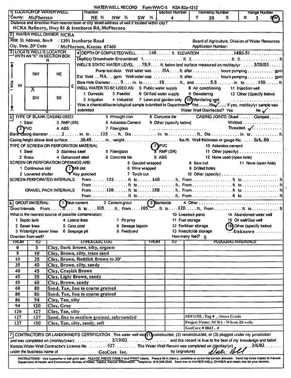
Specific Water Well Detail |
|
|
| Location Info | |||
| Owner: National Cooperative Refinery Assoc. | Status: Constructed | ||
| Location: T20S, R3W, Sec. 4, NE NW SW | County: McPherson | ||
| Directions: NCRA Refinery - from McPherson: Hwy 81 and Ironhorse Rd, McPherson | |||
| Latitude: 38.3396625 | Longitude: -97.6633627 | Datum NAD 27 | |
| Latitude: 38.3396709 | Longitude: -97.6636831 | Datum NAD 83 | |
| Longitude and latitude calculated by Survey from township-range-section-quarter calls. Only good to within the quarter call accuracy. | |||
| View well on interactive map | |||
| General Info | ||
| Well Depth: 140 ft. | Elevation: 1486.51 ft. | |
| Static Water Level: 78.9 ft. | Est. Yield: gpm. | |
| Comp. Date: 19-Feb-2003 | Well Use: Monitoring well/observation/piezometer | |
| DWR Applic. #: | Other ID: MW 115 S | |
| Driller Info | ||
| Driller: GeoCore Services Inc. | License #: 527 | |
| Scanned Form | View scan |
|
Chemical Sample Submitted?:
Water Well disinfected?: | ||
| Casing Info | ||
| Casing Type:
Casing Joints: |
Diam: in. to ft | |
| Casing height above land surface: in
Casing Weight: lbs/ft Wall thickness or gauge no.: | ||
| Screen and Perforation Info | ||
| Screen Type: | Screen Openings: | |
| Screen-perforated intervals | From: ft to ft | |
| Gravel pack intervals | From: ft to ft | |
| Grout Info | ||
| Grout used: | From: to ft | |
| Source of Possible Contamination | ||
| Source: | ||
| Direction from well: | Distance: ft | |
| Lithologic Log
(Log data entered by KGS.) | ||
| From: 0 ft. to 5 ft. | silty clay, dark brown, organic | |
| From: 5 ft. to 10 ft. | silty clay, brown, with trace sand | |
| From: 10 ft. to 35 ft. | clay, brown, reddish brown to 30 feet | |
| From: 35 ft. to 40 ft. | silty sandy clay, brown | |
| From: 40 ft. to 45 ft. | clay, grayish brown | |
| From: 45 ft. to 55 ft. | sandy clay, light brown | |
| From: 55 ft. to 60 ft. | sandy clay, brown | |
| From: 60 ft. to 80 ft. | fine to coarse sand, tan | |
| From: 80 ft. to 86 ft. | fine to coarse sand, tan | |
| From: 86 ft. to 94 ft. | silty clay, tan | |
| From: 94 ft. to 120 ft. | clay, gray | |
| From: 120 ft. to 127 ft. | silty clay, tan | |
| From: 127 ft. to 137 ft. | fine to medium sand, subrounded | |
| From: 137 ft. to 150 ft. | silty sandy clay, tan, soft | |