|
|
|
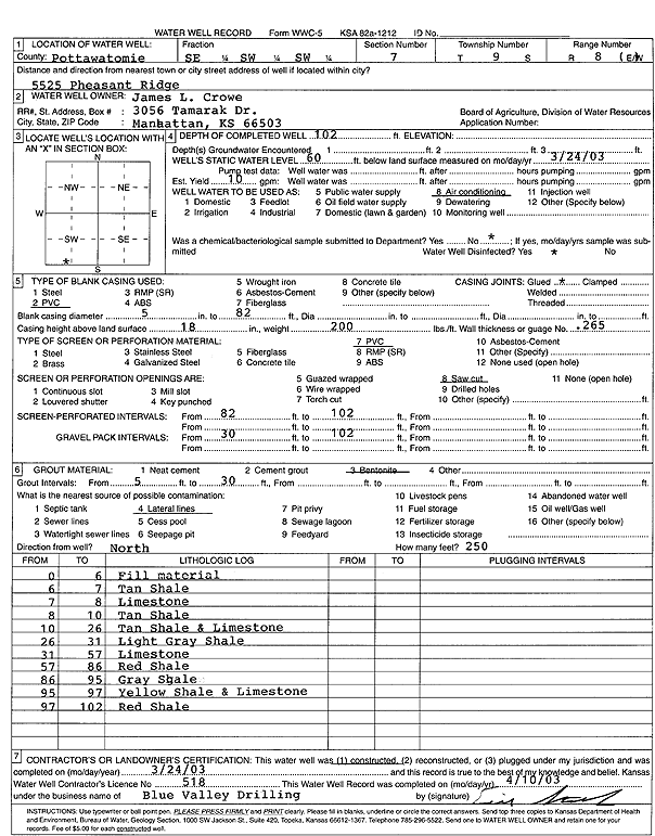
Specific Water Well Detail |
|
|
| Location Info | |||
| Owner: Crowe, James L. | Status: Constructed | ||
| Location: T9S, R8E, Sec. 7, SE SW SW | County: Pottawatomie | ||
| Directions: 5525 Pheasant Ridge, Manhattan | |||
| Latitude: 39.2774839 | Longitude: -96.5824939 | Datum NAD 27 | |
| Latitude: 39.2774803 | Longitude: -96.5827755 | Datum NAD 83 | |
| Longitude and latitude calculated by Survey from township-range-section-quarter calls. Only good to within the quarter call accuracy. | |||
| View well on interactive map | |||
| General Info | ||
| Well Depth: 102 ft. | Elevation: ft. | |
| Static Water Level: 60 ft. | Est. Yield: 10 gpm. | |
| Comp. Date: 24-Mar-2003 | Well Use: Air Conditioning | |
| DWR Applic. #: | Other ID: | |
| Driller Info | ||
| Driller: Blue Valley Drilling | License #: 518 | |
| Scanned Form | View scan |
|
Chemical Sample Submitted?:
Water Well disinfected?: | ||
| Casing Info | ||
| Casing Type:
Casing Joints: |
Diam: in. to ft | |
| Casing height above land surface: in
Casing Weight: lbs/ft Wall thickness or gauge no.: | ||
| Screen and Perforation Info | ||
| Screen Type: | Screen Openings: | |
| Screen-perforated intervals | From: ft to ft | |
| Gravel pack intervals | From: ft to ft | |
| Grout Info | ||
| Grout used: | From: to ft | |
| Source of Possible Contamination | ||
| Source: | ||
| Direction from well: | Distance: ft | |
| Lithologic Log
(Log data entered by KGS.) | ||
| From: 0 ft. to 6 ft. | fill material | |
| From: 6 ft. to 7 ft. | tan shale | |
| From: 7 ft. to 8 ft. | limestone | |
| From: 8 ft. to 10 ft. | tan shale | |
| From: 10 ft. to 26 ft. | tan shale and limestone | |
| From: 26 ft. to 31 ft. | light gray shale | |
| From: 31 ft. to 57 ft. | limestone | |
| From: 57 ft. to 86 ft. | red shale | |
| From: 86 ft. to 95 ft. | gray shale | |
| From: 95 ft. to 97 ft. | yellow shale and limestone | |
| From: 97 ft. to 102 ft. | red shale | |