|
|
|
Specific Water Well Detail |
|
|
| Location Info | |||
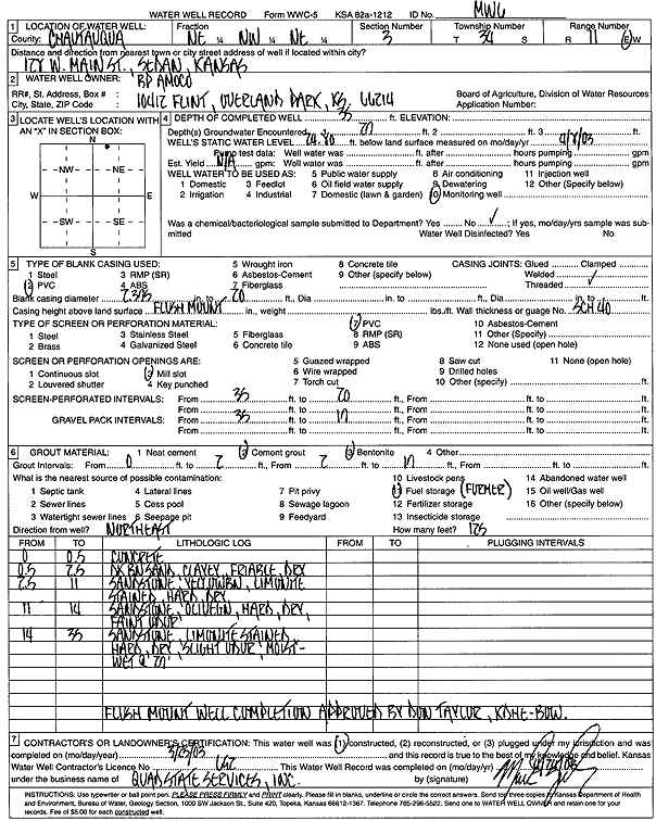
| Owner: BP Amoco | Status: Constructed | ||
| Location: T34S, R11E, Sec. 3, NE NW NE | County: Chautauqua | ||
| Directions: 128 W Main St, Sedan | |||
| Latitude: 37.1259586 | Longitude: -96.1869166 | Datum NAD 27 | |
| Latitude: 37.1260116 | Longitude: -96.1871861 | Datum NAD 83 | |
| Longitude and latitude calculated by Survey from township-range-section-quarter calls. Only good to within the quarter call accuracy. | |||
| View well on interactive map | |||
| General Info | ||
| Well Depth: 35 ft. | Elevation: ft. | |
| Static Water Level: 24.8 ft. | Est. Yield: gpm. | |
| Comp. Date: 25-Mar-2003 | Well Use: Monitoring well/observation/piezometer | |
| DWR Applic. #: | Other ID: MW 6 | |
| Driller Info | ||
| Driller: Quad State Services, Inc. | License #: 692 | |
| Scanned Form | View scan |
|
Chemical Sample Submitted?:
Water Well disinfected?: | ||
| Casing Info | ||
| Casing Type:
Casing Joints: |
Diam: in. to ft | |
| Casing height above land surface: in
Casing Weight: lbs/ft Wall thickness or gauge no.: | ||
| Screen and Perforation Info | ||
| Screen Type: | Screen Openings: | |
| Screen-perforated intervals | From: ft to ft | |
| Gravel pack intervals | From: ft to ft | |
| Grout Info | ||
| Grout used: | From: to ft | |
| Source of Possible Contamination | ||
| Source: | ||
| Direction from well: | Distance: ft | |
| Lithologic Log
(Log data entered by KGS.) | ||
| From: 0 ft. to .5 ft. | Concrete | |
| From: .5 ft. to 2.5 ft. | Dark brown sand, clayey, friable, dry | |
| From: 2.5 ft. to 11 ft. | Sandstone, yellow brown, limonite stained, hard, dry | |
| From: 11 ft. to 14 ft. | Sandstone, olive green, hard, dry, faint odor | |
| From: 14 ft. to 35 ft. | Sandstone, limonite stained, hard, dry, slight odor, moist-wet at 29 ft | |