|
|
|
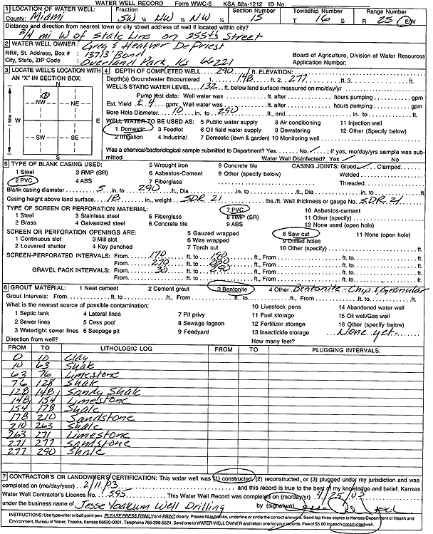
Specific Water Well Detail |
|
|
| Location Info | |||
| Owner: DePriest, Greg and Heather | Status: Constructed | ||
| Location: T16S, R25E, Sec. 15, SW NW NW | County: Miami | ||
| Directions: from State Line: .75 mi W on 255th St | |||
| Latitude: 38.6613389 | Longitude: -94.6373082 | Datum NAD 27 | |
| Latitude: 38.6613498 | Longitude: -94.637542 | Datum NAD 83 | |
| Longitude and latitude calculated by Survey from township-range-section-quarter calls. Only good to within the quarter call accuracy. | |||
| View well on interactive map | |||
| General Info | ||
| Well Depth: 290 ft. | Elevation: ft. | |
| Static Water Level: 132 ft. | Est. Yield: 4 gpm. | |
| Comp. Date: 11-Feb-2003 | Well Use: Domestic | |
| DWR Applic. #: | Other ID: | |
| Driller Info | ||
| Driller: Jesse Yoakum Well Drilling | License #: 595 | |
| Scanned Form | View scan |
|
Chemical Sample Submitted?:
Water Well disinfected?: | ||
| Casing Info | ||
| Casing Type:
Casing Joints: |
Diam: in. to ft | |
| Casing height above land surface: in
Casing Weight: lbs/ft Wall thickness or gauge no.: | ||
| Screen and Perforation Info | ||
| Screen Type: | Screen Openings: | |
| Screen-perforated intervals | From: ft to ft | |
| Gravel pack intervals | From: ft to ft | |
| Grout Info | ||
| Grout used: | From: to ft | |
| Source of Possible Contamination | ||
| Source: | ||
| Direction from well: | Distance: ft | |
| Lithologic Log
(Log data entered by KGS.) | ||
| From: 0 ft. to 10 ft. | clay | |
| From: 10 ft. to 63 ft. | shale | |
| From: 63 ft. to 76 ft. | limestone | |
| From: 76 ft. to 128 ft. | shale | |
| From: 128 ft. to 148 ft. | sandy shale | |
| From: 148 ft. to 154 ft. | limestone | |
| From: 154 ft. to 178 ft. | shale | |
| From: 178 ft. to 210 ft. | sandstone | |
| From: 210 ft. to 263 ft. | shale | |
| From: 263 ft. to 271 ft. | limestone | |
| From: 271 ft. to 277 ft. | sandstone | |
| From: 277 ft. to 290 ft. | shale | |