|
|
|
Specific Water Well Detail |
|
|
| Location Info | |||
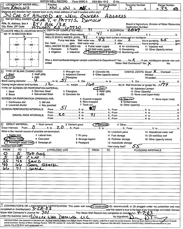
| Owner: Domsch, Gene T. and Patti S. | Status: Constructed | ||
| Location: T3S, R33W, Sec. 17, NW NW NE | County: Rawlins | ||
| Directions: RT 1, Box 13B, Atwood - SW corner of Atwood | |||
| Latitude: 39.7985386 | Longitude: -101.0453511 | Datum NAD 27 | |
| Latitude: 39.7985399 | Longitude: -101.0457857 | Datum NAD 83 | |
| Longitude and latitude calculated by Survey from township-range-section-quarter calls. Only good to within the quarter call accuracy. | |||
| View well on interactive map | |||
| General Info | ||
| Well Depth: 71 ft. | Elevation: 2869 ft. | |
| Static Water Level: 41 ft. | Est. Yield: gpm. | |
| Comp. Date: 28-Mar-2003 | Well Use: Domestic, Lawn and Garden | |
| DWR Applic. #: | Other ID: | |
| Driller Info | ||
| Driller: Wilcox Well Drilling, LLC | License #: 701 | |
| Scanned Form | View scan |
|
Chemical Sample Submitted?:
Water Well disinfected?: | ||
| Casing Info | ||
| Casing Type:
Casing Joints: |
Diam: in. to ft | |
| Casing height above land surface: in
Casing Weight: lbs/ft Wall thickness or gauge no.: | ||
| Screen and Perforation Info | ||
| Screen Type: | Screen Openings: | |
| Screen-perforated intervals | From: ft to ft | |
| Gravel pack intervals | From: ft to ft | |
| Grout Info | ||
| Grout used: | From: to ft | |
| Source of Possible Contamination | ||
| Source: | ||
| Direction from well: | Distance: ft | |
| Lithologic Log
(Log data entered by KGS.) | ||
| From: 0 ft. to 5 ft. | top soil | |
| From: 5 ft. to 35 ft. | clay | |
| From: 35 ft. to 40 ft. | sand | |
| From: 40 ft. to 66 ft. | good gravel | |
| From: 66 ft. to 71 ft. | shale | |