|
|
|
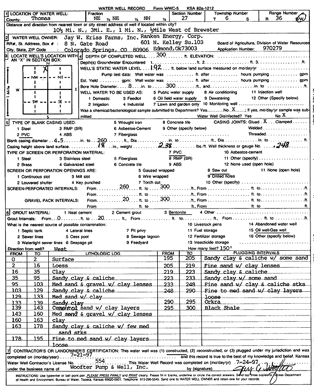
Specific Water Well Detail |
|
|
| Location Info | |||
| Owner: Ranken Energy Corp. | Status: Constructed | ||
| Location: T6S, R36W, Sec. 27, NE NE NW | County: Thomas | ||
| Directions: from Brewster: 10.5 mi N, 3 mi E, 1 mi N, .5 mi W | |||
| Latitude: 39.5106415 | Longitude: -101.3253109 | Datum NAD 27 | |
| Latitude: 39.5106415 | Longitude: -101.3257507 | Datum NAD 83 | |
| Longitude and latitude calculated by Survey from township-range-section-quarter calls. Only good to within the quarter call accuracy. | |||
| View well on interactive map | |||
| General Info | ||
| Well Depth: 300 ft. | Elevation: ft. | |
| Static Water Level: 192 ft. | Est. Yield: gpm. | |
| Comp. Date: 21-Jul-1997 | Well Use: Oil Field Water Supply | |
| DWR Applic. #: | Other ID: | |
| Links | |
| No Wizard information available. | |
| View info from WIMAS Water Right Data base... | |
| Driller Info | ||
| Driller: Jay C. Woofter Pump & Well, Inc. | License #: 554 | |
| Scanned Form | View scan |
|
Chemical Sample Submitted?:
Water Well disinfected?: | ||
| Casing Info | ||
| Casing Type:
Casing Joints: |
Diam: in. to ft | |
| Casing height above land surface: in
Casing Weight: lbs/ft Wall thickness or gauge no.: | ||
| Screen and Perforation Info | ||
| Screen Type: | Screen Openings: | |
| Screen-perforated intervals | From: ft to ft | |
| Gravel pack intervals | From: ft to ft | |
| Grout Info | ||
| Grout used: | From: to ft | |
| Source of Possible Contamination | ||
| Source: | ||
| Direction from well: | Distance: ft | |
| Lithologic Log
(Log data entered by KGS.) | ||
| From: 0 ft. to 2 ft. | surface | |
| From: 2 ft. to 16 ft. | loess | |
| From: 16 ft. to 35 ft. | clay | |
| From: 35 ft. to 95 ft. | sandy clay and caliche | |
| From: 95 ft. to 103 ft. | medium sand and gravel with clay lenses | |
| From: 103 ft. to 129 ft. | sandy clay and caliche | |
| From: 129 ft. to 133 ft. | medium sand with clay | |
| From: 133 ft. to 139 ft. | sandy clay | |
| From: 139 ft. to 143 ft. | cemented sand with clay layers | |
| From: 143 ft. to 160 ft. | medium sand and gravel with clay lenses | |
| From: 160 ft. to 163 ft. | clay | |
| From: 163 ft. to 178 ft. | sandy clay and caliche with few medium sand streaks | |
| From: 178 ft. to 195 ft. | fine to medium sand with clay layers, loose | |
| From: 195 ft. to 205 ft. | sandy clay and caliche with some sand | |
| From: 205 ft. to 219 ft. | fine sand with clay lenses | |
| From: 219 ft. to 223 ft. | sandy clay and caliche | |
| From: 223 ft. to 233 ft. | sandy clay with some sand | |
| From: 233 ft. to 248 ft. | fine sand with clay and caliche streaks | |
| From: 248 ft. to 290 ft. | fine to medium sand with clay layers | |
| From: 290 ft. to 295 ft. | ochre | |
| From: 295 ft. to 300 ft. | black shale | |