|
|
|
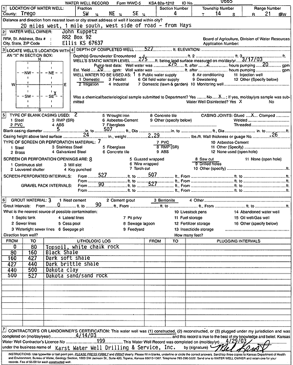
Specific Water Well Detail |
|
|
| Location Info | |||
| Owner: Kuppetz, John | Status: Constructed | ||
| Location: T14S, R21W, Sec. 4, SW NE SE | County: Trego | ||
| Directions: from Hays: 20 mi W, 1 mi S, W side of Rd | |||
| Latitude: 38.8606442 | Longitude: -99.6542956 | Datum NAD 27 | |
| Latitude: 38.8606556 | Longitude: -99.6546878 | Datum NAD 83 | |
| Longitude and latitude calculated by Survey from township-range-section-quarter calls. Only good to within the quarter call accuracy. | |||
| View well on interactive map | |||
| General Info | ||
| Well Depth: 527 ft. | Elevation: ft. | |
| Static Water Level: 275 ft. | Est. Yield: 20 gpm. | |
| Comp. Date: 14-Apr-2003 | Well Use: Domestic | |
| DWR Applic. #: | Other ID: | |
| Driller Info | ||
| Driller: Karst Water Well Drilling & Service, Inc. | License #: 199 | |
| Scanned Form | View scan |
|
Chemical Sample Submitted?:
Water Well disinfected?: | ||
| Casing Info | ||
| Casing Type:
Casing Joints: |
Diam: in. to ft | |
| Casing height above land surface: in
Casing Weight: lbs/ft Wall thickness or gauge no.: | ||
| Screen and Perforation Info | ||
| Screen Type: | Screen Openings: | |
| Screen-perforated intervals | From: ft to ft | |
| Gravel pack intervals | From: ft to ft | |
| Grout Info | ||
| Grout used: | From: to ft | |
| Source of Possible Contamination | ||
| Source: | ||
| Direction from well: | Distance: ft | |
| Lithologic Log
(Log data entered by KGS.) | ||
| From: 0 ft. to 80 ft. | topsoil, white chalk rock | |
| From: 80 ft. to 160 ft. | black shale | |
| From: 160 ft. to 427 ft. | dark soft shale | |
| From: 427 ft. to 440 ft. | dark brittle shale | |
| From: 440 ft. to 500 ft. | Dakota clay | |
| From: 500 ft. to 527 ft. | Dakota sand, sand rock | |