|
|
|
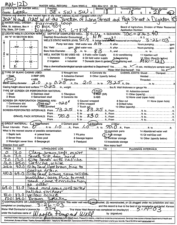
Specific Water Well Detail |
|
|
| Location Info | |||
| Owner: Farmers Coop | Status: Constructed | ||
| Location: T18S, R28W, Sec. 18, SE SW SW | County: Lane | ||
| Directions: from the Junction of Long Stand High St, Dighton: 302' N, 120' W | |||
| Latitude: 38.4830025 | Longitude: -100.4632394 | Datum NAD 27 | |
| Latitude: 38.4830193 | Longitude: -100.4636571 | Datum NAD 83 | |
| Longitude and latitude calculated by Survey from township-range-section-quarter calls. Only good to within the quarter call accuracy. | |||
| View well on interactive map | |||
| General Info | ||
| Well Depth: 83 ft. | Elevation: 2763.4 ft. | |
| Static Water Level: 55.9 ft. | Est. Yield: gpm. | |
| Comp. Date: 26-Mar-2003 | Well Use: Monitoring well/observation/piezometer | |
| DWR Applic. #: | Other ID: MW 12 D | |
| Driller Info | ||
| Driller: Jay C. Woofter Pump & Well, Inc. | License #: 554 | |
| Scanned Form | View scan |
|
Chemical Sample Submitted?:
Water Well disinfected?: | ||
| Casing Info | ||
| Casing Type:
Casing Joints: |
Diam: in. to ft | |
| Casing height above land surface: in
Casing Weight: lbs/ft Wall thickness or gauge no.: | ||
| Screen and Perforation Info | ||
| Screen Type: | Screen Openings: | |
| Screen-perforated intervals | From: ft to ft | |
| Gravel pack intervals | From: ft to ft | |
| Grout Info | ||
| Grout used: | From: to ft | |
| Source of Possible Contamination | ||
| Source: | ||
| Direction from well: | Distance: ft | |
| Lithologic Log
(Log data entered by KGS.) | ||
| From: 0 ft. to 3 ft. | Clay, brown, soft, moist | |
| From: 3 ft. to 7 ft. | Sandy silt, tan, hard | |
| From: 7 ft. to 13 ft. | Silty sand with caliche | |
| From: 13 ft. to 25 ft. | Caliche, white | |
| From: 25 ft. to 40 ft. | Silty sand, light brown, fine to coarse grained | |
| From: 40 ft. to 69 ft. | Silty sand, brown, some caliche nodules, very fine to medium sand, some cementation, no odor | |
| From: 69 ft. to 81 ft. | Sand, medium grained, well sorted, caliche stringer | |
| From: 81 ft. to 83 ft. | Yellow ochre | |
| From: 83 ft. to 84 ft. | Brown shale | |