|
|
|
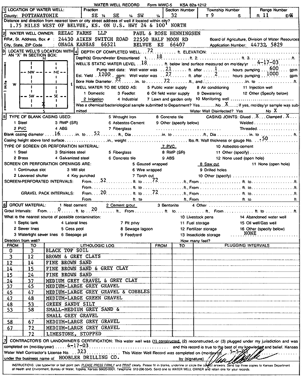
Specific Water Well Detail |
|
|
| Location Info | |||
| Owner: Rezac Farms LLP/Paul and Rose Henningsen | Status: Constructed | ||
| Location: T9S, R11E, Sec. 32, SE SE SW | County: Pottawatomie | ||
| Directions: from Belvue: 1.75 mi W, 100 feet N on US Hwy 24 | |||
| Latitude: 39.2177882 | Longitude: -96.2135538 | Datum NAD 27 | |
| Latitude: 39.2177848 | Longitude: -96.2138278 | Datum NAD 83 | |
| Longitude and latitude calculated by Survey from township-range-section-quarter calls. Only good to within the quarter call accuracy. | |||
| View well on interactive map | |||
| General Info | ||
| Well Depth: 72 ft. | Elevation: ft. | |
| Static Water Level: 18 ft. | Est. Yield: 1200 gpm. | |
| Comp. Date: 17-Apr-2003 | Well Use: Irrigation | |
| DWR Applic. #: 44732 and 5829 | Other ID: | |
| Links | |
| No Wizard information available. | |
| View info from WIMAS Water Right Data base... | |
| Driller Info | ||
| Driller: Daniel H. Hoobler Drilling Co. | License #: 323 | |
| Scanned Form | View scan |
|
Chemical Sample Submitted?:
Water Well disinfected?: | ||
| Casing Info | ||
| Casing Type:
Casing Joints: |
Diam: in. to ft | |
| Casing height above land surface: in
Casing Weight: lbs/ft Wall thickness or gauge no.: | ||
| Screen and Perforation Info | ||
| Screen Type: | Screen Openings: | |
| Screen-perforated intervals | From: ft to ft | |
| Gravel pack intervals | From: ft to ft | |
| Grout Info | ||
| Grout used: | From: to ft | |
| Source of Possible Contamination | ||
| Source: | ||
| Direction from well: | Distance: ft | |
| Lithologic Log
(Log data entered by KGS.) | ||
| From: 0 ft. to 3 ft. | black top soil | |
| From: 3 ft. to 12 ft. | brown and gray clay | |
| From: 12 ft. to 14 ft. | fine brown sand | |
| From: 14 ft. to 15 ft. | fine brown sand and gray clay | |
| From: 15 ft. to 24 ft. | fine brown sand | |
| From: 24 ft. to 37 ft. | medium gray gravel and gray clay | |
| From: 37 ft. to 45 ft. | medium-large gray gravel | |
| From: 45 ft. to 47 ft. | medium-large gray gravel and cobbles | |
| From: 47 ft. to 48 ft. | medium-large green gravel | |
| From: 48 ft. to 53 ft. | green sandy silt | |
| From: 53 ft. to 58 ft. | small-medium gray sand and small gray gravel | |
| From: 58 ft. to 67 ft. | medium-large gray gravel | |
| From: 67 ft. to 72 ft. | medium-large gray gravel | |
| From: 72 ft. to ft. | limestone | |