|
|
|
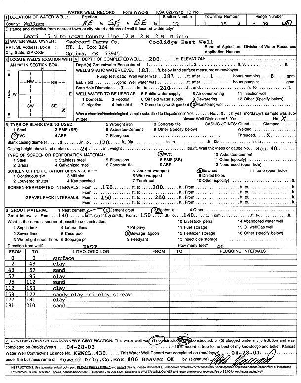
Specific Water Well Detail |
|
|
| Location Info | |||
| Owner: Seaboard Farms Co. | Status: Constructed | ||
| Location: T15S, R39W, Sec. 22, NE SE SE | County: Wallace | ||
| Directions: from Leoti: 15 mi N to Logan County Line, 12 mi W, 2 mi N, 2 mi W, then N into (Coolidge E Well) | |||
| Latitude: 38.7308449 | Longitude: -101.6327888 | Datum NAD 27 | |
| Latitude: 38.7308573 | Longitude: -101.633235 | Datum NAD 83 | |
| Longitude and latitude calculated by Survey from township-range-section-quarter calls. Only good to within the quarter call accuracy. | |||
| View well on interactive map | |||
| General Info | ||
| Well Depth: 200 ft. | Elevation: ft. | |
| Static Water Level: 183 ft. | Est. Yield: gpm. | |
| Comp. Date: 28-Apr-2003 | Well Use: Monitoring well/observation/piezometer | |
| DWR Applic. #: | Other ID: | |
| Driller Info | ||
| Driller: Howard Drilling Company AG, LLC | License #: 430 | |
| Scanned Form | View scan |
|
Chemical Sample Submitted?:
Water Well disinfected?: | ||
| Casing Info | ||
| Casing Type:
Casing Joints: |
Diam: in. to ft | |
| Casing height above land surface: in
Casing Weight: lbs/ft Wall thickness or gauge no.: | ||
| Screen and Perforation Info | ||
| Screen Type: | Screen Openings: | |
| Screen-perforated intervals | From: ft to ft | |
| Gravel pack intervals | From: ft to ft | |
| Grout Info | ||
| Grout used: | From: to ft | |
| Source of Possible Contamination | ||
| Source: | ||
| Direction from well: | Distance: ft | |
| Lithologic Log
(Log data entered by KGS.) | ||
| From: 0 ft. to 2 ft. | surface | |
| From: 2 ft. to 48 ft. | clay | |
| From: 48 ft. to 57 ft. | sand | |
| From: 57 ft. to 95 ft. | clay | |
| From: 95 ft. to 112 ft. | sand | |
| From: 112 ft. to 158 ft. | clay | |
| From: 158 ft. to 177 ft. | sandy clay and clay streaks | |
| From: 177 ft. to 181 ft. | clay | |
| From: 181 ft. to 210 ft. | sand | |