|
|
|
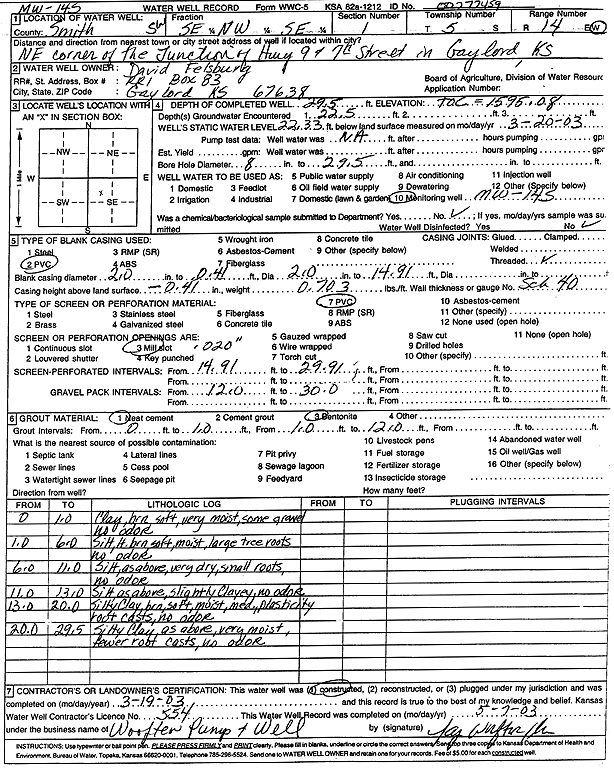
Specific Water Well Detail |
|
|
| Location Info | |||
| Owner: Dave Felsburg Shop | Status: Constructed | ||
| Location: T5S, R14W, Sec. 1, SE NW SE | County: Smith | ||
| Directions: NE corner of the Junction of Hwy 9 and 7th St, Gaylord | |||
| Latitude: 39.6447835 | Longitude: -98.8471475 | Datum NAD 27 | |
| Latitude: 39.6447947 | Longitude: -98.8475033 | Datum NAD 83 | |
| Longitude and latitude calculated by Survey from township-range-section-quarter calls. Only good to within the quarter call accuracy. | |||
| View well on interactive map | |||
| General Info | ||
| Well Depth: 29.5 ft. | Elevation: 1595.08 ft. | |
| Static Water Level: 22.33 ft. | Est. Yield: gpm. | |
| Comp. Date: 19-Mar-2003 | Well Use: Monitoring well/observation/piezometer | |
| DWR Applic. #: | Other ID: MW 14 S | |
| Driller Info | ||
| Driller: Jay C. Woofter Pump & Well, Inc. | License #: 554 | |
| Scanned Form | View scan |
|
Chemical Sample Submitted?:
Water Well disinfected?: | ||
| Casing Info | ||
| Casing Type:
Casing Joints: |
Diam: in. to ft | |
| Casing height above land surface: in
Casing Weight: lbs/ft Wall thickness or gauge no.: | ||
| Screen and Perforation Info | ||
| Screen Type: | Screen Openings: | |
| Screen-perforated intervals | From: ft to ft | |
| Gravel pack intervals | From: ft to ft | |
| Grout Info | ||
| Grout used: | From: to ft | |
| Source of Possible Contamination | ||
| Source: | ||
| Direction from well: | Distance: ft | |
| Lithologic Log
(Log data entered by KGS.) | ||
| From: 0 ft. to 1 ft. | clay, brown, soft, very moist, some gravel, no odor | |
| From: 1 ft. to 6 ft. | silt, light brown, soft, moist, large tree roots, no odor | |
| From: 6 ft. to 11 ft. | silt, light brown, soft, very dry, small roots, no odor | |
| From: 11 ft. to 13 ft. | silt, light brown, slightly clayey, no odor | |
| From: 13 ft. to 20 ft. | silty clay, brown, soft, moist, medium plasticity, root casts, no odor | |
| From: 20 ft. to 29.5 ft. | silty clay, brown, soft, very moist, fewer root casts, no odor | |