|
|
|
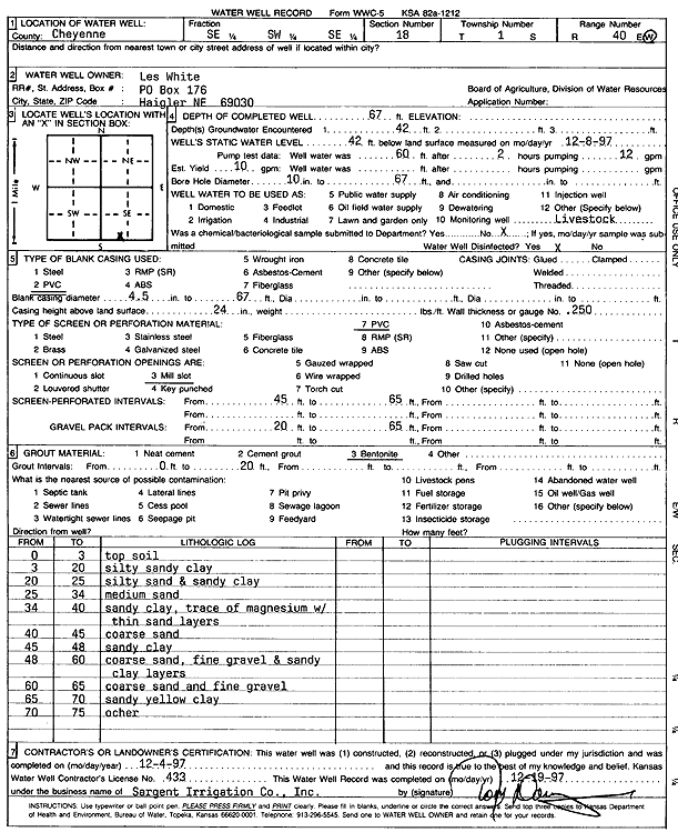
Specific Water Well Detail |
|
|
| Location Info | |||
| Owner: White, Les | Status: Constructed | ||
| Location: T1S, R40W, Sec. 18, SE SW SE | County: Cheyenne | ||
| Directions: | |||
| Latitude: 39.9604489 | Longitude: -101.8479631 | Datum NAD 27 | |
| Latitude: 39.9604408 | Longitude: -101.8484185 | Datum NAD 83 | |
| Longitude and latitude calculated by Survey from township-range-section-quarter calls. Only good to within the quarter call accuracy. | |||
| View well on interactive map | |||
| General Info | ||
| Well Depth: 67 ft. | Elevation: ft. | |
| Static Water Level: 42 ft. | Est. Yield: 10 gpm. | |
| Comp. Date: 04-Dec-1997 | Well Use: Domestic, Livestock | |
| DWR Applic. #: | Other ID: | |
| Driller Info | ||
| Driller: Chas. Sargent Irrigation Co., Inc. | License #: 433 | |
| Scanned Form | View scan |
|
Chemical Sample Submitted?:
Water Well disinfected?: | ||
| Casing Info | ||
| Casing Type:
Casing Joints: |
Diam: in. to ft | |
| Casing height above land surface: in
Casing Weight: lbs/ft Wall thickness or gauge no.: | ||
| Screen and Perforation Info | ||
| Screen Type: | Screen Openings: | |
| Screen-perforated intervals | From: ft to ft | |
| Gravel pack intervals | From: ft to ft | |
| Grout Info | ||
| Grout used: | From: to ft | |
| Source of Possible Contamination | ||
| Source: | ||
| Direction from well: | Distance: ft | |
| Lithologic Log
(Log data entered by KGS.) | ||
| From: 0 ft. to 3 ft. | Topsoil | |
| From: 3 ft. to 20 ft. | Silty sandy clay | |
| From: 20 ft. to 25 ft. | Silty sand and sandy clay | |
| From: 25 ft. to 34 ft. | Medium sand | |
| From: 34 ft. to 40 ft. | Sandy clay, trace of magnesium with thin sand layers | |
| From: 40 ft. to 45 ft. | coarse sand | |
| From: 45 ft. to 48 ft. | sandy clay | |
| From: 48 ft. to 60 ft. | coarse sand, fine gravel and sandy clay layers | |
| From: 60 ft. to 65 ft. | Coarse sand and fine gravel | |
| From: 65 ft. to 70 ft. | Sandy yellow clay | |
| From: 70 ft. to 75 ft. | Ochre | |