|
|
|
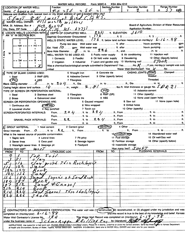
Specific Water Well Detail |
|
|
| Location Info | |||
| Owner: Wilkens, Ellsworth | Status: Constructed | ||
| Location: T2S, R37W, Sec. 9, SE SE SE | County: Cheyenne | ||
| Directions: from Bird City, 5 mi E, 8 mi N, and 1 mi W | |||
| Latitude: 39.8881639 | Longitude: -101.4672599 | Datum NAD 27 | |
| Latitude: 39.8881599 | Longitude: -101.4677023 | Datum NAD 83 | |
| Longitude and latitude calculated by Survey from township-range-section-quarter calls. Only good to within the quarter call accuracy. | |||
| View well on interactive map | |||
| General Info | ||
| Well Depth: 224 ft. | Elevation: 3610 ft. | |
| Static Water Level: 176 ft. | Est. Yield: 10 gpm. | |
| Comp. Date: 16-Jun-1998 | Well Use: Domestic, Livestock | |
| DWR Applic. #: | Other ID: | |
| Driller Info | ||
| Driller: Schoenrogge Drilling, Inc. | License #: 184 | |
| Scanned Form | View scan |
|
Chemical Sample Submitted?:
Water Well disinfected?: | ||
| Casing Info | ||
| Casing Type:
Casing Joints: |
Diam: in. to ft | |
| Casing height above land surface: in
Casing Weight: lbs/ft Wall thickness or gauge no.: | ||
| Screen and Perforation Info | ||
| Screen Type: | Screen Openings: | |
| Screen-perforated intervals | From: ft to ft | |
| Gravel pack intervals | From: ft to ft | |
| Grout Info | ||
| Grout used: | From: to ft | |
| Source of Possible Contamination | ||
| Source: | ||
| Direction from well: | Distance: ft | |
| Lithologic Log
(Log data entered by KGS.) | ||
| From: 0 ft. to 3 ft. | Topsoil | |
| From: 3 ft. to 51 ft. | Clay | |
| From: 51 ft. to 116 ft. | Clay with thin rock layers | |
| From: 116 ft. to 122 ft. | Sand | |
| From: 122 ft. to 124 ft. | Rock | |
| From: 124 ft. to 136 ft. | Sand | |
| From: 136 ft. to 184 ft. | Sand layers of sand rock | |
| From: 184 ft. to 187 ft. | Rock | |
| From: 187 ft. to 212 ft. | Sand and gravel | |
| From: 212 ft. to 214 ft. | Rock | |
| From: 214 ft. to 224 ft. | Sand, gravel thin shale layers | |
| From: 224 ft. to 226 ft. | Shale | |