|
|
|
Specific Water Well Detail |
|
|
| Location Info | |||
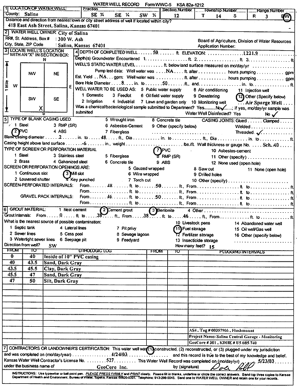
| Owner: City of Salina | Status: Constructed | ||
| Location: T14S, R3W, Sec. 12, SE SE SW | County: Saline | ||
| Directions: 418 E Ash St, Salina | |||
| Latitude: 38.8424775 | Longitude: -97.6040078 | Datum NAD 27 | |
| Latitude: 38.8424802 | Longitude: -97.6043202 | Datum NAD 83 | |
| Longitude and latitude calculated by Survey from township-range-section-quarter calls. Only good to within the quarter call accuracy. | |||
| View well on interactive map | |||
| General Info | ||
| Well Depth: 50 ft. | Elevation: 1221.9 ft. | |
| Static Water Level: ft. | Est. Yield: gpm. | |
| Comp. Date: 24-Apr-2003 | Well Use: Environmental Remediation, Air Sparge | |
| DWR Applic. #: | Other ID: AS 4 | |
| Driller Info | ||
| Driller: GeoCore Services Inc. | License #: 527 | |
| Scanned Form | View scan |
|
Chemical Sample Submitted?:
Water Well disinfected?: | ||
| Casing Info | ||
| Casing Type:
Casing Joints: |
Diam: in. to ft | |
| Casing height above land surface: in
Casing Weight: lbs/ft Wall thickness or gauge no.: | ||
| Screen and Perforation Info | ||
| Screen Type: | Screen Openings: | |
| Screen-perforated intervals | From: ft to ft | |
| Gravel pack intervals | From: ft to ft | |
| Grout Info | ||
| Grout used: | From: to ft | |
| Source of Possible Contamination | ||
| Source: | ||
| Direction from well: | Distance: ft | |
| Lithologic Log
(Log data entered by KGS.) | ||
| From: 0 ft. to 40 ft. | no recovery | |
| From: 40 ft. to 43.5 ft. | sand, dark gray | |
| From: 43.5 ft. to 45.5 ft. | clay, dark gray | |
| From: 45.5 ft. to 47 ft. | sand, dark gray | |
| From: 47 ft. to 50 ft. | silt, dark gray | |