|
|
|
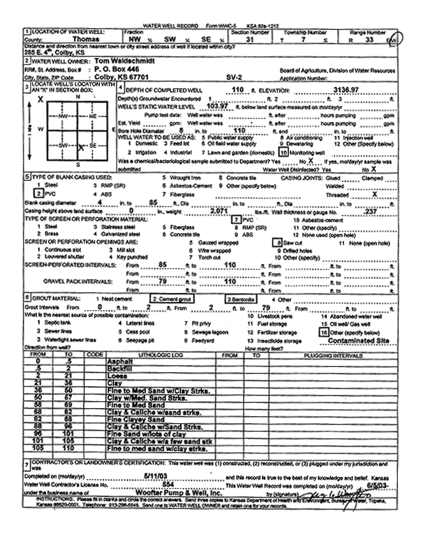
Specific Water Well Detail |
|
|
| Location Info | |||
| Owner: Waldschmidt, Tom | Status: Constructed | ||
| Location: T7S, R33W, Sec. 31, NW SW SE | County: Thomas | ||
| Directions: 285 E 4th, Colby | |||
| Latitude: 39.3970264 | Longitude: -101.0439917 | Datum NAD 27 | |
| Latitude: 39.3970301 | Longitude: -101.0444245 | Datum NAD 83 | |
| Longitude and latitude calculated by Survey from township-range-section-quarter calls. Only good to within the quarter call accuracy. | |||
| View well on interactive map | |||
| General Info | ||
| Well Depth: 110 ft. | Elevation: 3136.97 ft. | |
| Static Water Level: 103.97 ft. | Est. Yield: gpm. | |
| Comp. Date: 11-May-2003 | Well Use: Monitoring well/observation/piezometer | |
| DWR Applic. #: | Other ID: SV 2 | |
| Driller Info | ||
| Driller: Jay C. Woofter Pump & Well, Inc. | License #: 554 | |
| Scanned Form | View scan |
|
Chemical Sample Submitted?:
Water Well disinfected?: | ||
| Casing Info | ||
| Casing Type:
Casing Joints: |
Diam: in. to ft | |
| Casing height above land surface: in
Casing Weight: lbs/ft Wall thickness or gauge no.: | ||
| Screen and Perforation Info | ||
| Screen Type: | Screen Openings: | |
| Screen-perforated intervals | From: ft to ft | |
| Gravel pack intervals | From: ft to ft | |
| Grout Info | ||
| Grout used: | From: to ft | |
| Source of Possible Contamination | ||
| Source: | ||
| Direction from well: | Distance: ft | |
| Lithologic Log
(Log data entered by KGS.) | ||
| From: 0 ft. to .5 ft. | asphalt | |
| From: .5 ft. to 2 ft. | backfill | |
| From: 2 ft. to 21 ft. | loess | |
| From: 21 ft. to 36 ft. | clay | |
| From: 36 ft. to 50 ft. | fine to medium sand with clay streaks | |
| From: 59 ft. to 67 ft. | clay with medium sand streaks | |
| From: 67 ft. to 69 ft. | fine to medium sand | |
| From: 69 ft. to 82 ft. | clay and caliche with sand streaks | |
| From: 82 ft. to 88 ft. | fine clayey sand | |
| From: 88 ft. to 96 ft. | clay and caliche with sand streaks | |
| From: 96 ft. to 101 ft. | fine sand with lots of clay | |
| From: 101 ft. to 105 ft. | clay and caliche with a few sand streaks | |
| From: 105 ft. to 110 ft. | fine to medium sand with clay streaks | |