|
|
|
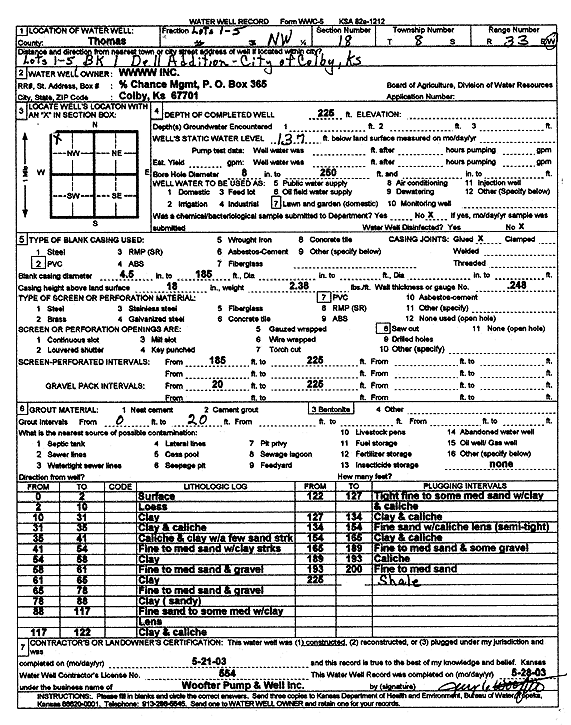
Specific Water Well Detail |
|
|
| Location Info | |||
| Owner: WWWW Inc./Chance Mgmt | Status: Constructed | ||
| Location: T8S, R33W, Sec. 18, NW | County: Thomas | ||
| Directions: Lot 1-5, BK 1 Dell Addition, Colby | |||
| Latitude: 39.3615769 | Longitude: -101.0500209 | Datum NAD 27 | |
| Latitude: 39.3615809 | Longitude: -101.0504537 | Datum NAD 83 | |
| Longitude and latitude calculated by Survey from township-range-section-quarter calls. Only good to within the quarter call accuracy. | |||
| View well on interactive map | |||
| General Info | ||
| Well Depth: 225 ft. | Elevation: ft. | |
| Static Water Level: 137 ft. | Est. Yield: gpm. | |
| Comp. Date: 21-May-2003 | Well Use: Domestic, Lawn and Garden | |
| DWR Applic. #: | Other ID: | |
| Driller Info | ||
| Driller: Jay C. Woofter Pump & Well, Inc. | License #: 554 | |
| Scanned Form | View scan |
|
Chemical Sample Submitted?:
Water Well disinfected?: | ||
| Casing Info | ||
| Casing Type:
Casing Joints: |
Diam: in. to ft | |
| Casing height above land surface: in
Casing Weight: lbs/ft Wall thickness or gauge no.: | ||
| Screen and Perforation Info | ||
| Screen Type: | Screen Openings: | |
| Screen-perforated intervals | From: ft to ft | |
| Gravel pack intervals | From: ft to ft | |
| Grout Info | ||
| Grout used: | From: to ft | |
| Source of Possible Contamination | ||
| Source: | ||
| Direction from well: | Distance: ft | |
| Lithologic Log
(Log data entered by KGS.) | ||
| From: 0 ft. to 2 ft. | surface | |
| From: 2 ft. to 10 ft. | loess | |
| From: 10 ft. to 31 ft. | clay | |
| From: 31 ft. to 38 ft. | clay and caliche | |
| From: 38 ft. to 41 ft. | caliche and clay with a few sand streaks | |
| From: 41 ft. to 54 ft. | fine to medium sand with clay streaks | |
| From: 54 ft. to 58 ft. | clay | |
| From: 58 ft. to 61 ft. | fine to medium sand and gravel | |
| From: 61 ft. to 65 ft. | clay | |
| From: 65 ft. to 78 ft. | fine to medium sand and gravel | |
| From: 78 ft. to 88 ft. | clay, sandy | |
| From: 88 ft. to 117 ft. | fine sand with some medium with clay lens | |
| From: 117 ft. to 122 ft. | clay and caliche | |
| From: 122 ft. to 127 ft. | tight fine to some medium sand with clay and caliche | |
| From: 127 ft. to 134 ft. | clay and caliche | |
| From: 134 ft. to 154 ft. | fine sand with caliche lens, semi tight | |
| From: 154 ft. to 165 ft. | clay and caliche | |
| From: 165 ft. to 189 ft. | fine to medium sand and some gravel | |
| From: 189 ft. to 193 ft. | caliche | |
| From: 193 ft. to 200 ft. | fine to medium sand | |
| From: 200 ft. to 225 ft. | shale | |