|
|
|
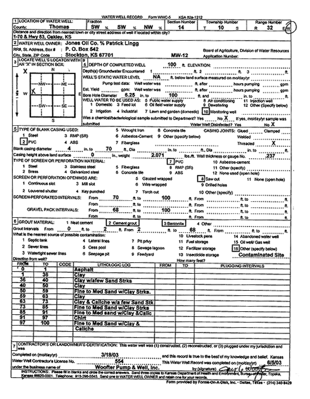
Specific Water Well Detail |
|
|
| Location Info | |||
| Owner: JJ Oil Company 6 | Status: Constructed | ||
| Location: T10S, R32W, Sec. 14, SW SW NW | County: Thomas | ||
| Directions: I 70 and Hwy 83, Oakley | |||
| Latitude: 39.1849086 | Longitude: -100.8686225 | Datum NAD 27 | |
| Latitude: 39.1849155 | Longitude: -100.8690494 | Datum NAD 83 | |
| Longitude and latitude calculated by Survey from township-range-section-quarter calls. Only good to within the quarter call accuracy. | |||
| View well on interactive map | |||
| General Info | ||
| Well Depth: 100 ft. | Elevation: ft. | |
| Static Water Level: ft. | Est. Yield: gpm. | |
| Comp. Date: 18-Mar-2003 | Well Use: Monitoring well/observation/piezometer | |
| DWR Applic. #: | Other ID: MW 12 | |
| Driller Info | ||
| Driller: Jay C. Woofter Pump & Well, Inc. | License #: 554 | |
| Scanned Form | View scan |
|
Chemical Sample Submitted?:
Water Well disinfected?: | ||
| Casing Info | ||
| Casing Type:
Casing Joints: |
Diam: in. to ft | |
| Casing height above land surface: in
Casing Weight: lbs/ft Wall thickness or gauge no.: | ||
| Screen and Perforation Info | ||
| Screen Type: | Screen Openings: | |
| Screen-perforated intervals | From: ft to ft | |
| Gravel pack intervals | From: ft to ft | |
| Grout Info | ||
| Grout used: | From: to ft | |
| Source of Possible Contamination | ||
| Source: | ||
| Direction from well: | Distance: ft | |
| Lithologic Log
(Log data entered by KGS.) | ||
| From: 0 ft. to 1 ft. | asphalt | |
| From: 1 ft. to 36 ft. | clay | |
| From: 36 ft. to 40 ft. | clay with a few sand streaks | |
| From: 40 ft. to 50 ft. | clay | |
| From: 50 ft. to 59 ft. | fine to medium sand with clay streaks | |
| From: 59 ft. to 63 ft. | clay | |
| From: 63 ft. to 73 ft. | clay and caliche with a few sand streaks | |
| From: 73 ft. to 85 ft. | fine to medium sand with clay streaks | |
| From: 85 ft. to 91 ft. | fine to medium sand with clay and caliche | |
| From: 91 ft. to 97 ft. | chert | |
| From: 97 ft. to 100 ft. | fine to medium sand with clay and caliche | |