|
|
|
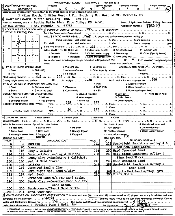
Specific Water Well Detail |
|
|
| Location Info | |||
| Owner: Murfin Drilling/Raile, Bertha | Status: Constructed | ||
| Location: T2S, R41W, Sec. 32, C NW | County: Cheyenne | ||
| Directions: from St. Francis, 5 mi N, 5 mi W, 0.5 mi S, and 0.5 mi W | |||
| Latitude: 39.8398343 | Longitude: -101.9504653 | Datum NAD 27 | |
| Latitude: 39.8398266 | Longitude: -101.9509245 | Datum NAD 83 | |
| Longitude and latitude calculated by Survey from township-range-section-quarter calls. Only good to within the quarter call accuracy. | |||
| View well on interactive map | |||
| General Info | ||
| Well Depth: 295 ft. | Elevation: ft. | |
| Static Water Level: 245 ft. | Est. Yield: gpm. | |
| Comp. Date: 20-Feb-1998 | Well Use: Oil Field Water Supply | |
| DWR Applic. #: 980039 | Other ID: | |
| Links | |
| No Wizard information available. | |
| View info from WIMAS Water Right Data base... | |
| Driller Info | ||
| Driller: Jay C. Woofter Pump & Well, Inc. | License #: 554 | |
| Scanned Form | View scan |
|
Chemical Sample Submitted?:
Water Well disinfected?: | ||
| Casing Info | ||
| Casing Type:
Casing Joints: |
Diam: in. to ft | |
| Casing height above land surface: in
Casing Weight: lbs/ft Wall thickness or gauge no.: | ||
| Screen and Perforation Info | ||
| Screen Type: | Screen Openings: | |
| Screen-perforated intervals | From: ft to ft | |
| Gravel pack intervals | From: ft to ft | |
| Grout Info | ||
| Grout used: | From: to ft | |
| Source of Possible Contamination | ||
| Source: | ||
| Direction from well: | Distance: ft | |
| Lithologic Log
(Log data entered by KGS.) | ||
| From: 0 ft. to 2 ft. | Surface | |
| From: 2 ft. to 20 ft. | Loess | |
| From: 20 ft. to 116 ft. | Clay and caliche | |
| From: 116 ft. to 121 ft. | Cemented sand with clay and caliche | |
| From: 121 ft. to 150 ft. | Sandy clay with sandstone and caliche streak | |
| From: 150 ft. to 160 ft. | Medium and sand gravel | |
| From: 160 ft. to 165 ft. | Caliche | |
| From: 165 ft. to 169 ft. | Cemented sand and clay | |
| From: 169 ft. to 182 ft. | Semi-tight medium sand with clay | |
| From: 182 ft. to 187 ft. | Medium sand | |
| From: 187 ft. to 190 ft. | Cemented sand with a few sand streaks | |
| From: 190 ft. to 200 ft. | Sandy clay with cemented sand and a few sand streaks | |
| From: 200 ft. to 210 ft. | Sandstone with clay and sand streaks | |
| From: 210 ft. to 211 ft. | Hard sandstone | |
| From: 211 ft. to 228 ft. | Semi-tight sandstone with clay and a few medium sand streaks | |
| From: 228 ft. to 230 ft. | Hard cemented sand | |
| From: 230 ft. to 246 ft. | Semi-tight sandstone with clay and fine sand streaks | |
| From: 246 ft. to 248 ft. | Hard cemented sand | |
| From: 248 ft. to 253 ft. | Semi-tight sandstone with clay and some sand | |
| From: 253 ft. to 285 ft. | Fine to medium sand with clay layers | |
| From: 285 ft. to 295 ft. | Black shale | |