|
|
|
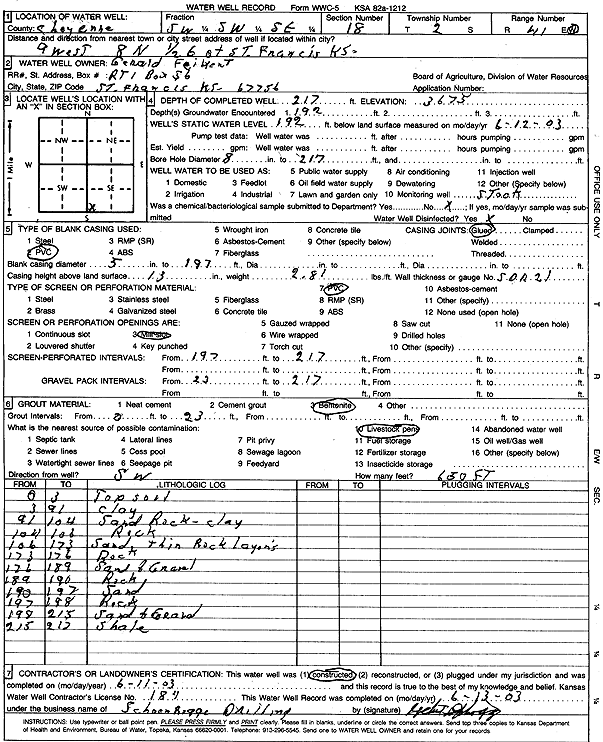
Specific Water Well Detail |
|
|
| Location Info | |||
| Owner: Feikert, Gerald | Status: Constructed | ||
| Location: T2S, R41W, Sec. 18, SW SW SE | County: Cheyenne | ||
| Directions: from St Francis: 9 mi W, 8 mi N, and 0.5 mi E | |||
| Latitude: 39.8733677 | Longitude: -101.9630439 | Datum NAD 27 | |
| Latitude: 39.8733597 | Longitude: -101.9635039 | Datum NAD 83 | |
| Longitude and latitude calculated by Survey from township-range-section-quarter calls. Only good to within the quarter call accuracy. | |||
| View well on interactive map | |||
| General Info | ||
| Well Depth: 217 ft. | Elevation: 3675 ft. | |
| Static Water Level: 192 ft. | Est. Yield: gpm. | |
| Comp. Date: 11-Jun-2003 | Well Use: Domestic, Livestock | |
| DWR Applic. #: | Other ID: | |
| Driller Info | ||
| Driller: Schoenrogge Drilling, Inc. | License #: 184 | |
| Scanned Form | View scan |
|
Chemical Sample Submitted?:
Water Well disinfected?: | ||
| Casing Info | ||
| Casing Type:
Casing Joints: |
Diam: in. to ft | |
| Casing height above land surface: in
Casing Weight: lbs/ft Wall thickness or gauge no.: | ||
| Screen and Perforation Info | ||
| Screen Type: | Screen Openings: | |
| Screen-perforated intervals | From: ft to ft | |
| Gravel pack intervals | From: ft to ft | |
| Grout Info | ||
| Grout used: | From: to ft | |
| Source of Possible Contamination | ||
| Source: | ||
| Direction from well: | Distance: ft | |
| Lithologic Log
(Log data entered by KGS.) | ||
| From: 0 ft. to 3 ft. | top soil | |
| From: 3 ft. to 91 ft. | clay | |
| From: 91 ft. to 104 ft. | sand rock, clay | |
| From: 104 ft. to 106 ft. | rock | |
| From: 106 ft. to 173 ft. | sand with thin rock layers | |
| From: 173 ft. to 176 ft. | rock | |
| From: 176 ft. to 189 ft. | sand and gravel | |
| From: 189 ft. to 190 ft. | rock | |
| From: 190 ft. to 197 ft. | sand | |
| From: 197 ft. to 198 ft. | rock | |
| From: 198 ft. to 215 ft. | sand and gravel | |
| From: 215 ft. to 217 ft. | shale | |