|
|
|
Specific Water Well Detail |
|
|
| Location Info | |||
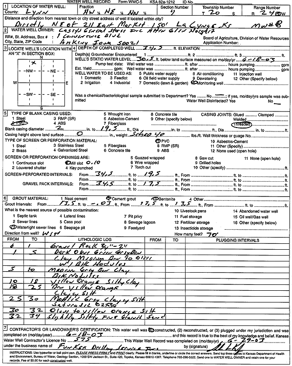
| Owner: Casey's General Store | Status: Constructed | ||
| Location: T20S, R24E, Sec. 4, NW NE NW | County: Linn | ||
| Directions: from 211 E Market, La Cygne: 150' NE | |||
| Latitude: 38.3443786 | Longitude: -94.7644149 | Datum NAD 27 | |
| Latitude: 38.3443994 | Longitude: -94.7646515 | Datum NAD 83 | |
| Longitude and latitude calculated by Survey from township-range-section-quarter calls. Only good to within the quarter call accuracy. | |||
| View well on interactive map | |||
| General Info | ||
| Well Depth: 34.5 ft. | Elevation: ft. | |
| Static Water Level: 30.5 ft. | Est. Yield: gpm. | |
| Comp. Date: 18-Jun-2003 | Well Use: Monitoring well/observation/piezometer | |
| DWR Applic. #: | Other ID: MW 8 | |
| Driller Info | ||
| Driller: Funkee Drilling Service | License #: 575 | |
| Scanned Form | View scan |
|
Chemical Sample Submitted?:
Water Well disinfected?: | ||
| Casing Info | ||
| Casing Type:
Casing Joints: |
Diam: in. to ft | |
| Casing height above land surface: in
Casing Weight: lbs/ft Wall thickness or gauge no.: | ||
| Screen and Perforation Info | ||
| Screen Type: | Screen Openings: | |
| Screen-perforated intervals | From: ft to ft | |
| Gravel pack intervals | From: ft to ft | |
| Grout Info | ||
| Grout used: | From: to ft | |
| Source of Possible Contamination | ||
| Source: | ||
| Direction from well: | Distance: ft | |
| Lithologic Log
(Log data entered by KGS.) | ||
| From: 0 ft. to 1 ft. | gravel and rock | |
| From: 1 ft. to 5 ft. | dark olive green-gray brown clay, medium brown to orange, with black nodules | |
| From: 5 ft. to 10 ft. | medium gray brown clay, black nodules | |
| From: 10 ft. to 18 ft. | yellow orange silty clay | |
| From: 18 ft. to 25 ft. | brown yellow orange clayey silt | |
| From: 25 ft. to 30 ft. | mottled gray clayey silt, saturated at 27-30 feet | |
| From: 30 ft. to 32 ft. | olive to yellow orange silt | |
| From: 32 ft. to 34 ft. | slightly silty fine sand | |