|
|
|
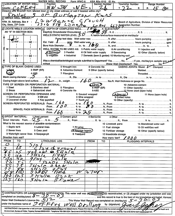
Specific Water Well Detail |
|
|
| Location Info | |||
| Owner: Crouch, Lawrence | Status: Constructed | ||
| Location: T22S, R15E, Sec. 26, NW SW NE | County: Coffey | ||
| Directions: from Burlington: 5 mi S | |||
| Latitude: 38.1073363 | Longitude: -95.7286175 | Datum NAD 27 | |
| Latitude: 38.1073623 | Longitude: -95.7288811 | Datum NAD 83 | |
| Longitude and latitude calculated by Survey from township-range-section-quarter calls. Only good to within the quarter call accuracy. | |||
| View well on interactive map | |||
| General Info | ||
| Well Depth: 160 ft. | Elevation: ft. | |
| Static Water Level: 50 ft. | Est. Yield: 1 gpm. | |
| Comp. Date: 30-May-2003 | Well Use: Domestic | |
| DWR Applic. #: | Other ID: | |
| Driller Info | ||
| Driller: Jeffrey Well Drilling | License #: 512 | |
| Scanned Form | View scan |
|
Chemical Sample Submitted?:
Water Well disinfected?: | ||
| Casing Info | ||
| Casing Type:
Casing Joints: |
Diam: in. to ft | |
| Casing height above land surface: in
Casing Weight: lbs/ft Wall thickness or gauge no.: | ||
| Screen and Perforation Info | ||
| Screen Type: | Screen Openings: | |
| Screen-perforated intervals | From: ft to ft | |
| Gravel pack intervals | From: ft to ft | |
| Grout Info | ||
| Grout used: | From: to ft | |
| Source of Possible Contamination | ||
| Source: | ||
| Direction from well: | Distance: ft | |
| Lithologic Log
(Log data entered by KGS.) | ||
| From: 0 ft. to 2 ft. | soil | |
| From: 2 ft. to 15 ft. | clay and gravel | |
| From: 15 ft. to 25 ft. | yellow shale | |
| From: 25 ft. to 40 ft. | shale, light | |
| From: 40 ft. to 50 ft. | gray shale | |
| From: 50 ft. to 55 ft. | sandy shale | |
| From: 55 ft. to 75 ft. | shale, dark | |
| From: 75 ft. to 88 ft. | shale, gray | |
| From: 88 ft. to 100 ft. | sandy limestone | |
| From: 100 ft. to 125 ft. | shale, dark | |
| From: 125 ft. to 160 ft. | shale, brown | |