|
|
|
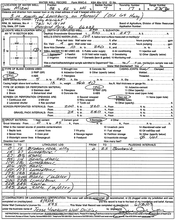
Specific Water Well Detail |
|
|
| Location Info | |||
| Owner: Albright, Troy | Status: Constructed | ||
| Location: T17S, R23E, Sec. 7, SE SE NE | County: Miami | ||
| Directions: from Louisburg: 3 mi S on Metcalf | |||
| Latitude: 38.5863371 | Longitude: -94.9016461 | Datum NAD 27 | |
| Latitude: 38.5863498 | Longitude: -94.9018873 | Datum NAD 83 | |
| Longitude and latitude calculated by Survey from township-range-section-quarter calls. Only good to within the quarter call accuracy. | |||
| View well on interactive map | |||
| General Info | ||
| Well Depth: 230 ft. | Elevation: ft. | |
| Static Water Level: 100 ft. | Est. Yield: 4 gpm. | |
| Comp. Date: 09-May-2003 | Well Use: Domestic | |
| DWR Applic. #: | Other ID: | |
| Driller Info | ||
| Driller: Jesse Yoakum Well Drilling | License #: 595 | |
| Scanned Form | View scan |
|
Chemical Sample Submitted?:
Water Well disinfected?: | ||
| Casing Info | ||
| Casing Type:
Casing Joints: |
Diam: in. to ft | |
| Casing height above land surface: in
Casing Weight: lbs/ft Wall thickness or gauge no.: | ||
| Screen and Perforation Info | ||
| Screen Type: | Screen Openings: | |
| Screen-perforated intervals | From: ft to ft | |
| Gravel pack intervals | From: ft to ft | |
| Grout Info | ||
| Grout used: | From: to ft | |
| Source of Possible Contamination | ||
| Source: | ||
| Direction from well: | Distance: ft | |
| Lithologic Log
(Log data entered by KGS.) | ||
| From: 0 ft. to 15 ft. | Broken rock, clay | |
| From: 15 ft. to 27 ft. | Limestone | |
| From: 27 ft. to 85 ft. | Shale | |
| From: 85 ft. to 114 ft. | Sandy shale | |
| From: 114 ft. to 126 ft. | Limestone | |
| From: 126 ft. to 150 ft. | Shale | |
| From: 150 ft. to 173 ft. | Limestone | |
| From: 173 ft. to 198 ft. | Shale | |
| From: 198 ft. to 200 ft. | Slate (water) | |
| From: 200 ft. to 228 ft. | Limestone | |
| From: 228 ft. to 245 ft. | Shale | |
| From: 245 ft. to 250 ft. | Slate (water) | |