|
|
|
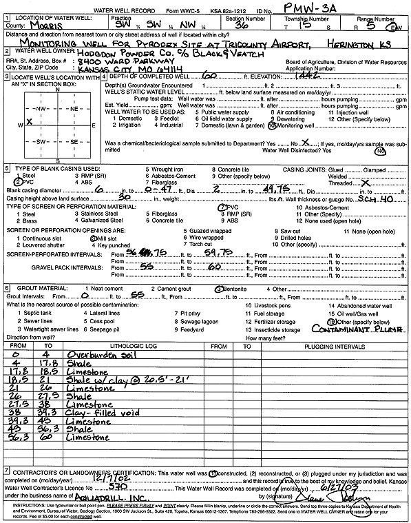
Specific Water Well Detail |
|
|
| Location Info | |||
| Owner: Hodgdon Powder Co - Black & Veatch | Status: Constructed | ||
| Location: T15S, R5E, Sec. 36, SW SW NW | County: Morris | ||
| Directions: Pyrodex Site at Tri County Airport, Herington | |||
| Latitude: 38.7041828 | Longitude: -96.8333226 | Datum NAD 27 | |
| Latitude: 38.7041897 | Longitude: -96.8336115 | Datum NAD 83 | |
| Longitude and latitude calculated by Survey from township-range-section-quarter calls. Only good to within the quarter call accuracy. | |||
| View well on interactive map | |||
| General Info | ||
| Well Depth: 60 ft. | Elevation: 1442 ft. | |
| Static Water Level: ft. | Est. Yield: gpm. | |
| Comp. Date: 07-Dec-2002 | Well Use: Monitoring well/observation/piezometer | |
| DWR Applic. #: | Other ID: PMW 3 A | |
| Driller Info | ||
| Driller: Aquadrill, Inc. | License #: 570 | |
| Scanned Form | View scan |
|
Chemical Sample Submitted?:
Water Well disinfected?: | ||
| Casing Info | ||
| Casing Type:
Casing Joints: |
Diam: in. to ft | |
| Casing height above land surface: in
Casing Weight: lbs/ft Wall thickness or gauge no.: | ||
| Screen and Perforation Info | ||
| Screen Type: | Screen Openings: | |
| Screen-perforated intervals | From: ft to ft | |
| Gravel pack intervals | From: ft to ft | |
| Grout Info | ||
| Grout used: | From: to ft | |
| Source of Possible Contamination | ||
| Source: | ||
| Direction from well: | Distance: ft | |
| Lithologic Log
(Log data entered by KGS.) | ||
| From: 0 ft. to 4 ft. | overburden soil | |
| From: 4 ft. to 17.8 ft. | shale | |
| From: 17.8 ft. to 18.5 ft. | limestone | |
| From: 18.5 ft. to 21 ft. | shale with clay at 20.5-21 feet | |
| From: 21 ft. to 26 ft. | limestone | |
| From: 26 ft. to 27.5 ft. | shale | |
| From: 27.5 ft. to 38 ft. | limestone | |
| From: 38 ft. to 39.3 ft. | clay-filled void | |
| From: 39.3 ft. to 45 ft. | limestone | |
| From: 45 ft. to 56.3 ft. | shale | |
| From: 56.3 ft. to 60 ft. | limestone | |